hidden
|
Moskovskoe Freeway
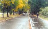
MOSKOVSKOE FREEWAY, between Pobedy Square and line of the Circular Railway, continues Moskovsky Avenue. It appeared in the first quarter of the 18th century as the road to Sarskaya Myza (Tsarskoe Selo) and further on to Novgorod and Moscow (in the
|
|
|
|
|
hidden
|
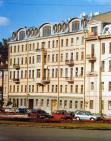
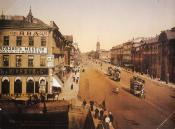
Moskovsky Avenue
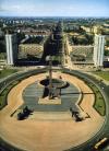
MOSKOVSKY AVENUE (in 1918-50 - Mezhdunarodny Avenue, in 1950-56 - Stalina Avenue, after I.V. Stalin), from Sennaya Square to Pobedy Square, one of the main thoroughfares of St
|
|
|
|
|
hidden
|
Moskovsky District
MOSKOVSKY DISTRICT is an administrative territorial unit of St. Petersburg. (Its territory administration is located at 129 Moskovsky Avenue) It was founded in 1919, and its present-day borders were established in 1965
|
|
|
|
|
hidden
|
Moskovsky Park of Victory
MOSKOVSKY PARK OF VICTORY (188 Moskovsky Avenue) is located in the south of St. Petersburg, between Moskovsky Avenue and Gagarin Avenue. A project of a district Park of Culture and Recreation
|
|
|
|
|
hidden
|
Mozhaysky, settlement
MOZHAYSKY, a former urban settlement, known as Duderhof until 1950; incorporated in 1973 into the Krasnoselsky District of Leningrad. Located 30 kilometres southwest of the city centre
|
|
|
|
|
hidden
|
Murino
MURINO, a rural settlement (and former village) on Toksovskoe Freeway, 0.5 km from the city borders, adjoining the north-east outskirts of St. Petersburg. The Murinsky Stream, railway station in St
|
|
|
|
|
hidden
|
Murinsky Stream
MURINSKY STREAM, a water course in the north of St. Petersburg and a tributary to the Okhta River. The name comes from the village of Murino. The stream heads from Sosnovka Park
|
|
|
|
|
hidden
|
Murzinka
MURZINKA, a river in the north-east of St. Petersburg. In the 1720s, it was named after a country house of the same name. The length is about five kilometres, the width varies from one to three kilometres, at its mouth up
|
|
|
|
|
hidden
|
Murzinka, river
MURZINKA, a locality enclosed by Zaporozhskaya Street, the Neva River, the Murzinka River and the railway line linking Obukhovo and Rybatskoe. The name originates from the grange (later to become a village) of Murzinka, which belonged to A.I
|
|
|
|
|
hidden
|
Muzhestva Square
MUZHESTVA SQUARE known as Murinskaya or Spasskaya Square before 1965, between Karbysheva Street, Politekhnicheskaya Street, Second Murinsky Avenue, Toreza Avenue, and Nepokorennykh Avenue
|
|
|
|
|
hidden
|
Mytninskaya Embankment
MYTNINSKAYA EMBANKMENT stretching from Kronverksky Avenue to Dobrolyubova Avenue along Kronverksky Channel and the Malaya Neva River in the southern extremity of Petrogradsky Island at the approach of Birzhevoy Bridge
|
|
|
|
|
hidden
|
Narodnogo Opolchenia Avenue
NARODNOGO OPOLCHENIA AVENUE translated as Avenue of the People's Volunteer Corps, lying between Krasnoputilovskaya Street and Letchika Pilyutova Street and crossing districts of Knyazhevo, Dachnoe, Ulyanka, Ligovo, and Sosnovaya Polyana
|
|
|
|
|
hidden
|
Narvskaya Zastava
NARVSKAYA ZASTAVA, the historical name of the northern part of Kirovsky District. It descends to an outpost on the post road to Narva and Reval (today Tallin), that was located on the place of present-day Stachek Square
|
|
|
|
|
hidden
|
Narvsky Avenue
NARVSKY AVENUE known as Novo-Peterhofsky Avenue before the 1880s, between Staro-Petergofsky Avenue and Stachek Square. It was named after the town of Narva. The avenue was laid in the first half of the 19th century as a part of Petergofsky Avenue
|
|
|
|
|
hidden
|
Natural sights
NATURAL SIGHTS, natural formations, typical of certain processes and phenomena and as a rule specific within surrounding scenery; they can be divided into geological, geomorphological, botanic, hydrological sights etc
|
|
|
|
|
hidden
|
Nekrasova Street
NEKRASOVA STREET, known as Basseynaya Street before 1918, located between Liteyny Avenue and Grechesky Avenue. It was named after N. A. Nekrasov. It appeared in the first third of the 18th century leading to the pools that were opened to supply
|
|
|
|
|
hidden
|
Nepokorennykh Avenue
NEPOKORENNYKH AVENUE translated as the Avenue of the Unconquered, a part of the central ring road running between Muzhestva Square and Piskarevsky Avenue and crossing Kushelevka and Piskarevka
|
|
|
|
|
hidden
|
Neva Bay
NEVA BAY is a shallow eastern end of the Gulf of Finland located between the Neva River and Kotlin Island (traditionally referred by citizens of St. Petersburg and sailors as "Marquis's Puddle")
|
|
|
|
|
hidden
|
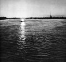
Neva, river
NEVA, a river in the north-west of Russia, around which the city of St. Petersburg is located at the river mouth. The river issues from the Shlisselburg Bay of Lake Ladoga and enters the Neva Bay of the Gulf of Finland
|
|
|
|
|
hidden
|
Nevskaya Zastava
NEVSKAYA ZASTAVA (outpost), a historical name of the territory along the left bank of the Neva River from Alexander Nevsky Lavra to Rybatskoe. It encompasses the following historical districts and localities: Steklyanny Settlement (Glass Settlement)
|
|
|
|
|
hidden
|
Nevsky District
NEVSKY DISTRICT, an administrative and territorial unit of St. Petersburg, with its administration located at 163 Obukhovskoy Oborony Avenue. Formed in 1917, it was called Volodarsky District in 1920-49
|
|
|
|
|
hidden
|
Nevsky Forest Park
NEVSKY FOREST PARK is located on the North bank of the Neva, to the north-east of the village Novosaratovka (Vsevolozhsky District of the Leningrad Region). Nevsky Forest Park was laid out in 1937
|
|
|
|
|
hidden
|
Nevsky Prospect
NEVSKY PROSPECT known as Bolshaya Pershpektivnaya Road or Bolshaya Pershpektiva until 1738, Nevskaya Prospektivaya Street or Nevskaya Perspektiva in 1738-1780s, and 25 October Avenue in 1918-44 so named in memory of the October Revolution of 1917
|
|
|
|
|
hidden
|
Nevsky Settlement
NEVSKY SETTLEMENT (in the present-day academic literature, it is also called the Nevsky Estuary), a Russian trade settlement at the confluence of the Okhta River and the Neva River
|
|
|
|
|
hidden
|
New Holland
NEW HOLLAND (103 Moika River Embankment), a complex of storage facilities situated on the cognominal island (with an area of approximately 3 hectares), appearing in 1720 after the laying out of the Admiralty and Kryukov canals of the Moika River
|
|
|
|
|
hidden
|
New Peterhof
NEW PETERHOF, part of the town of Petrodvorets, west of the Angliisky Park, also the name of a railway station along the Saint Petersburg - Lomonosov line. The Petrodvorets Watch Plant and the Popov Higher Navy School of Radioelectronics are located
|
|
|
|
|
hidden
|
Nikolsky Garden
NIKOLSKY GARDEN is located in the centre of St. Petersburg between Kryukov Canal Embankment, Griboedova Canal Embankment, Rimsky-Korsakov Avenue and Nikolsky Lane. The total area of the garden is 1.7 hectares. It was laid out in the 18th century. St
|
|
|
|
|
hidden
|
Novaya Derevnya
NOVAYA DEREVNYA, a historical district in the north-west of St. Petersburg, on the right bank of the Bolshaya Nevka River, in the west it borders on Staraya Derevnya, in the east it is confined by the Chernaya Rechka River
|
|
|
|
|
hidden
|
Novo-Admiralteysky Island
NOVO-ADMIRALTEYSKY ISLAND, translated as New Admiralty Island, situated between the Bolshaya Neva River, Moika River, and Novo-Admiralteysky Canal. It was a part of Usadishche Island until the early 18th century
|
|
|
|
|
hidden
|
Novo-Admralty Canal
NOVO-ADMIRALTY CANAL (New Admiralty Canal) flowing from the confluence of the Moika River and the Admiraly Canal to the Bolshaya Neva was dug in the first quarter of the 18th century
|
|
|
|
|