hidden
|
Admiralty Canal
ADMIRALTY CANAL was dug from the eastern ditch of the Amiralty Fortress (today, the Dvortsovy Bridge ramp to the Palace Square) to the Moika River to connect the Admiralty Shipyard with Galerny Dvor (Galley Yard) and warehouses of New Holland
|
|
|
|
|
hidden
|
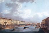
Bolshaya Neva
BOLSHAYA NEVA, the largest left branch of the the Neva river delta; a continuation of the Neva River below the Dvortsovaya Bridge. The Bolshaya Neva flows into the Neva Bay of the Gulf of Finland, in the area surrounded by Vasilievsky Island
|
|
|
|
|
hidden
|
Bolshaya Nevka
BOLSHAYA NEVKA, the extreme right branch of the Neva River delta, which flows off the main channel 500 metres below the Liteiny Bridge. It separates Vyborgskaya Side from Petrogradskaya Side and flows into the Neva Bay below the Spit of Elagin
|
|
|
|
|
hidden
|
Bumazhny Canal
Bumazhny Canal (Paper Canal) was dug between the Ekaterinhofka River and the Tarakanovka River for practical purposes in the second half of the 18th century. It bears its name from the Ekaterinhof Cotton Mill (today
|
|
|
|
|
hidden
|
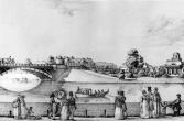
Canals (entry)
CANALS are artificial waterways built from the time of St. Petersburg's founding to drain low and swamp lands and create convenient access to ship construction materials and other cargoes (Peter the Great’s wish to create "a second Venice" another
|
|
|
|
|
hidden
|
Canals of Galley Yard
CANALS OF THE GALLEY YARD were dug at the beginning of the 18th century in the western end of Admiralty Island, at the place of the Galley Yard. In 1711 and 1716
|
|
|
|
|
hidden
|
Chernavka, river
CHERNAVKA, a river in the east of St. Petersburg, a tributary to the Okhta River. The length is about two kilometres; width in its lower course is up to 12 metres. The name was caused by the dark colour of the water
|
|
|
|
|
hidden
|
Chernaya Rechka River
CHERNAYA RECHKA, a river in the north-west of St. Petersburg. The name dates back to 1748. The river is a tributary of the Bolshaya Nevka River. Originally it sprang from Lake Dolgoe and flowed into the Bolshaya Nevka from the right
|
|
|
|
|
hidden
|
Chukhonka, river
CHUKHONKA, a river in the north-west of St. Petersburg, on Krestovsky Island. It was known from 1762 as the Chukhonskaya River, to assume the present-day name in the 19th century
|
|
|
|
|
hidden
|
Dachnaya, river
DACHNAYA, a river in the south-west of St. Petersburg, formerly a left tributary to the Krasnenkaya River. The river is drawn from the west of the village of Staropanovo
|
|
|
|
|
hidden
|
Dolgoye Lake
DOLGOYE LAKE (Long Lake) is located in the northern St. Petersburg at the crossing of Olkhovskaya Street and Koroleva Avenue. Before the 18th century, it was named Pitkyyarvi ("long lake")
|
|
|
|
|
hidden
|
Dudergofka, river
DUDERGOFKA (Duderhof, known as Dudorovka in the 18th century), a river in the south-west of St. Petersburg. The name originates from Duderhof Heights. The river emerges from Lake Duderhof (Dudergofskoe)
|
|
|
|
|
hidden
|
Dudergofsky Canal
DUDERHOFSKY CANAL was built during the improvement of the Peterhof Highway and Southern Primorsky Park. It was named after the Duderhofka River (the Canal covers the river's mouth)
|
|
|
|
|
hidden
|
Duderhof Lake (Krasnoye Selo)
Duderhof Lake is located in the southern end of Krasnoye Selo (in Mozhaysky and Villosi Villages) at true altitude of 79.9 meters. It has a natural lowering among moraine hills in the centre of Izhora Heights (hence the name Duderhof Heights)
|
|
|
|
|
hidden
|
Ekaterinhofka, river
EKATERINHOFKA, a river in the west of St. Petersburg. Originally called Chernaya Rechka, while its present name refers to the Ekaterinhof Palace. The river is a lateral channel of the Bolshaya Neva River: starting from the mouth of the latter and
|
|
|
|
|
hidden
|
Emelyanovka, river
EMELYANOVKA, a river to the south-west of St. Petersburg, in Avtovo. Its name has been known since 1772; it probably originates from the name of a landowner. The headwaters of the river used to be 1 kilometre westwards of the intersection of
|
|
|
|
|
hidden
|
Fontanka, river
FONTANKA (known as Bezymyanny Erik until 1712-14), river, a branch in the Neva river delta, which crosses the central part of the city. The river flows from the Neva on the left, beside the Summer Garden
|
|
|
|
|
hidden
|
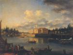
Galley Harbour
GALLEY HARBOUR is an engineering monument from the early 18th century. A rectangular pool located in the western part of Vasilievsky Island in the 18th - early 19th centuries served as a base for naval rowing vessels (galleys, hence the name)
|
|
|
|
|
hidden
|
Glukharka, river
GLUKHARKA, a river in the north-west of St. Petersburg. It used to flow off from the marshes situated west of Dolgoe lake. In the course of the building up of adjacent territory
|
|
|
|
|
hidden
|
Glukhoe Lake
GLUKHOYE LAKE, 1) located between Navalochnaya and Farforovskaya railway stations of the Moscow Line of Oktyabrskaya Railroad. Originally, Glukhoye Lake was 0.8 km long and wide
|
|
|
|
|
hidden
|
Gorely Stream
GORELY, a stream that flows in the north-east of St. Petersburg, near Rzhevka, leading it to be called Rzhevka River on occasion. The stream is a tributary of the Lubya River which forms part of the to the Okhta river basin
|
|
|
|
|
hidden
|
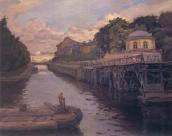
Grebnoy Canal
GREBNOY CANAL (Rowing Canal) is located in the northern part of Krestovsky Island in Primorsky Victory Park at the place of the former Vinnovka River. In 1938, the Grebnoy Canal was projected to be 2 km in length and run from the head of the
|
|
|
|
|
hidden
|
Griboyedova Canal
GRIBOYEDOVA CANAL (the Ekaterininsky Canal in 1767-1923) starts from the Moika River at the Field of Mars and flows into the Fontanka River at Malo-Kalinkin Bridge. It is 5 km long and 32 meters wide with water flow of 3.1 - 3.4 m3
|
|
|
|
|
hidden
|
Gulf of Finland
GULF OF FINLAND is the eastern part of the Baltic Sea running deep inland. The northern coast of the Gulf of Finland belongs to Finland; its southern part relates to Estonia and north-western and south eastern coasts are located in Russia
|
|
|
|
|
hidden
|
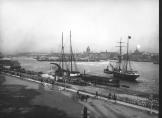
Gutuyevskaya Harbour
GUTUYEVSKAYA HARBOUR is an artificial rectangular Harbour (600x300 meters, 7 meters deep)located in the northern part of Gutuyev Island (hence the name). After its reconstruction during the building of the Morskoy Canal in 1874-75
|
|
|
|
|
hidden
|
Ivanovka, river
IVANOVKA, a river in the south-west of St. Petersburg, in the area of Sosnovaya Polyana and Ligovo. It was named in the 19th century after the village of Ivanovskaya
|
|
|
|
|
hidden
|
Izhora, river
IZHORA, also known as Inger river, a tributary to the Neva. The river draws its water through the Izhora Hills from a spring near Skvoritsa village of Gatchinsky District
|
|
|
|
|
hidden
|
Izhorka Bolshaya, river
IZHORKA BOLSHAYA, a river in the far South-East of Saint Petersburg eastwards from Kolpino. The name derives from the people of Izhora. Raising from the swamps northwards from the settlement of Krasny Bor
|
|
|
|
|
hidden
|
Kamenka, river
KAMENKA, a river in the south-west of St. Petersburg, running from Shuvalovo and Kamenka. It flows from Lake Nizhnee Bolshoe Suzdalskoe and runs through Novo-Orlovsky Forest Park and the pond of Shuvalovsky Pit
|
|
|
|
|
hidden
|
Kamenny Island Canals
KAMENNY ISLAND CANALS were built in the 18-19th centuries and intended to drain the territory, transport construction materials to palaces and estates and lay out park elements. The canal routes were repeatedly changed
|
|
|
|
|