hidden
|
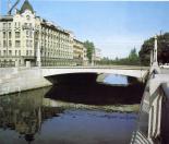
Smolenka, river
SMOLENKA, a river, which branches off the Malaya Neva from the left, below Tuchkov Bridge, and flows into the Neva Bay of the Gulf of Finland. The Smolenka separates Vasilievsky Island from Dekabristov Island. The river is 3.3 kilometres long
|
|
|
|
|
hidden
|
Smolenskoe Field, area
SMOLENSKOE FIELD, the historical name of the area located in the central part of Vasilievsky Island, between Nineteenth Line in the east, Smolenskoe Cemetery (hence the name) in the north and the harbour in the east
|
|
|
|
|
hidden
|
Smolenskoe Village
SMOLENSKOE VILLAGE, a historical region on the left bank of the Neva River, on the territory of Nevskaya Zastava, between Bolshoy Smolensky Avenue and Krupskoy Street
|
|
|
|
|
hidden
|
Smolnaya Embankment
SMOLNAYA EMBANKMENT, from Smolny Avenue to Robespierre Embankment. It received its name in 1887 after Smolny Cathedral (see Cathedral of the Renewal of the Jerusalem Holy Resurrection Temple)
|
|
|
|
|
hidden
|
Smolyachkovo
SMOLYACHKOVO (until 1948 Ino), the former village, since 1998 - a municipal establishment forming part of Kurortny District, in the resort zone on the north coast of the Gulf of Finland, on the boundary with Leningrad Region
|
|
|
|
|
hidden
|
Sofia
SOFIA, the historical name of the town of Pushkin to the south of Catherine Park, between Pavlovskoe Freeway and Krasnoselskoe Freeway. It was founded in 1785 by Empress Catherine II as a chief town of the district. In 1782-88, St
|
|
|
|
|
hidden
|
Soils
SOILS, topsoils and subsoils have retained their original composition outside city residential areas, and partly transformed in the city's gardens and parks. The soil cover of St
|
|
|
|
|
hidden
|
Solnechnoe, settlement
SOLNECHNOE (until 1948 Ollila), formerly a settlement, since 1998, a municipal unit of the Kurortny District, a resort area on the Gulf of Finland's northern coast; also a railway station. As of 2001, the population totalled 1,000 inhabitants
|
|
|
|
|
hidden
|
Solyanoy Lane
SOLYANOY LANE, from Tchaikovskogo Street to Pestelya Street. In the first quarter of the 18th century, a canal was located here which enclosed the area of the Partikulyarnaya (Civil) Shipyard. In the 1730s St
|
|
|
|
|
hidden
|
Sosnovaya Polyana
SOSNOVAYA POLYANA (Pine Glade), a park to the south-east of St. Petersburg between Veteranov Avenue and Narodnogo Opolchenia Avenue. From the west, it is confined by the Sosnovka River
|
|
|
|
|
hidden
|
Sosnovaya Polyana, the Park
SOSNOVAYA POLYANA is a park in the south-west of St. Petersburg between Veteranov Avenue and Narodnogo Opolcheniya Avenue. To the west is Sosnovka District. The total area is 58 hectares. The park was laid out in 1968
|
|
|
|
|
hidden
|
Sosnovka (Nevsky District)
SOSNOVKA, the historical name of the area to the south-east of St. Petersburg, between the Neva River, Narodnaya Street and Bolshevikov Avenue. It was named after the manor of A.I
|
|
|
|
|
hidden
|
Sosnovka Park
Sosnovka is a park between Svetlanovsky Avenue, Toreza Avenue, Severny Avenue and Tikhoretsky Avenue. The total area of the park is 303.5 hectares. Sosnovka is a remainder of the vast pine forests on sandy terraces in the northern part of St
|
|
|
|
|
hidden
|
Sosnovka (Vyborgsky District)
SOSNOVKA, a historical district in the north of St. Petersburg, in the north-east it joins Sosnovka park, in the south-west it is confined with Nauki Avenue, Gzhatskaya Street, Favorskogo Street, Politehnicheskaya Street and Toreza Avenue
|
|
|
|
|
hidden
|
South-West
South-West, the region of large-scale residential development, a part of Krasnoselsky District territory to the north of Petergofskoe Freeway and to the west from Stachek Avenue
|
|
|
|
|
hidden
|
Sovetskie Streets, First - Tenth
SOVETSKIE STREETS, First - Tenth (were called Rozhdestvenskie Streets from 1798 to 1923, after the Nativity of Our Lord Church, with the present-day name given on occasion of the 6th anniversary of the October Revolution of 1917)
|
|
|
|
|
hidden
|
Soyuza Pechatnikov Street
SOYUZA PECHATNIKOV STREET, from Kryukov Canal to Kulibina Square. Starting from 1739, the street bore the name Bolshaya Matrosskaya Street, renamed Torgovaya Street in 1776
|
|
|
|
|
hidden
|
Spassky Gorodensky Principality
SPASSKY GORODENSKY PRINCIPATE was one of the Orekhovsky District's principalities in Votic fifth on the territory of Novgorod. In the 15th -17th centuries, the complete right bank of the Neva (including the Lakhta Region and Nevsky Settlement) and a
|
|
|
|
|
hidden
|
Spassky Island
SPASSKY ISLAND, translated as Saviour Island, situated in the centre of St. Petersburg between the Fontanka River, Moika River, Griboedova Canal, and Kryukov Canal. It is over 230 hectares in area
|
|
|
|
|
hidden
|
Srednaya Nevka
SREDNYAYA NEVKA, branch in the Neva river delta. It comes off the Bolshaya Nevka between Elagin Island and Kamenny Island, separating them from each other and from Krestovsky Island as well
|
|
|
|
|
hidden
|
Sredny Avenue of Vasilievsky Island
SREDNY AVENUE OF VASILIEVSKY ISLAND (called Malaya Pershpektiva from the 1730s until the 1770s, known as Mussorgskogo Avenue in 1939-44), from Makarova Embankment to Nalichnaya Street
|
|
|
|
|
hidden
|
Srednyaya Rogatka
SREDNYAYA ROGATKA, the historical name of the area where Pulkovskoe Freeway and Moskovskoe Freeway intersect. In the 18th-19th centuries, an outpost was located there and the road was blocked with rogatka (turnpike) at night (hence the name)
|
|
|
|
|
hidden
|
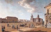
St. Isaac Square
St.ISAAC SQUARE (St. Isaac’s Square, in 1923-44, Vorovskogo Square), one of the central squares of St. Petersburg. Located between Admiralteisky Avenue and Mariinsky Palace
|
|
|
|
|
hidden
|
Stachek Avenue
STACHEK AVENUE, called Petergofskoe Highway until 1923, then known as Stachek Street until 1940, between Stachek Square and the place where Marshala Zhukova Avenue and Petergofskoe Freeway intersect
|
|
|
|
|
hidden
|
Stachek Square
STACHEK SQUARE, known as Narvskaya Square until 1923, at the intersection of Stachek Avenue, Narvsky Avenue and Staro-Petergofsky Avenue. The square assumed the present-day name in commemoration of the strike movement (the name of the square
|
|
|
|
|
hidden
|
Staraya Derevnya
STARAYA DEREVNYA, a historical district in the north-west of St. Petersburg, on the right bank of the Bolshaya Nevka River (opposite Elagin Island), to the west of Novaya Derevnya. In the 18th century, chancellor A. P
|
|
|
|
|
hidden
|
Staro-Petergofsky Avenue
STARO-PETERGOFSKY AVENUE, called Yunogo Proletariya Avenue from 1922 to 1933, then known as Gaza Avenue until 1991, in honour of I.I. Gaza, a Bolshevist and a worker of Putilov Plant (1894-1933). It leads from the Fontanka River to Stachek Square
|
|
|
|
|
hidden
|
Staropanovo
STAROPANOVO, the former village, located to the south of Ligovo Railway Station, along Tallinskoe Freeway (buildings 60-190). Appeared in the early 19th century (was also-called Maloe Ligovo and Ekaterininskaya)
|
|
|
|
|
hidden
|
Starozhilovka, river
STAROZHILOVKA, a river in the north of St. Petersburg, in the area of Shuvalovo and Pargolovo. The river draws its water from the southern slope of the Pargolovo Hills and flows into Lake Nizhnee Bolshoe Suzdalskoe
|
|
|
|
|
hidden
|
Steklyanny Settlement
STEKLYANNY SETTLEMENT (Glass Settlement), an area on the left bank of the Neva River, on the territory of Nevskaya Zastava, between Obvodny Canal in the north and Smolenskoe village in the south. In the 1770s, the territory belonged to G.A
|
|
|
|
|