hidden
|
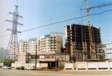
Central Ring Route
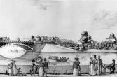
CENTRAL RING ROUTE, motor transport system, one of the main lines of St. Petersburg. The creation of Central Ring Route was to eliminate transit freight transport from the city
|
|
|
|
|
hidden
|
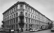
Chekhova Street
CHEKHOVA STREET, known as Ertelev Lane until 1923, between Zhukovskogo Street and Nekrasova Street. The street was laid in the second half of the 18th century. Its original name was derived from the last name of a house-owner
|
|
|
|
|
hidden
|
Chekushi
CHEKUSHI is an area located in the south-western part of Vasilievsky Island. Its name is known from the first part of the 18th century and is related to "chekushi" or "tokmochi"
|
|
|
|
|
hidden
|
Chernavka, river
CHERNAVKA, a river in the east of St. Petersburg, a tributary to the Okhta River. The length is about two kilometres; width in its lower course is up to 12 metres. The name was caused by the dark colour of the water
|
|
|
|
|
hidden
|
Chernaya Rechka River
CHERNAYA RECHKA, a river in the north-west of St. Petersburg. The name dates back to 1748. The river is a tributary of the Bolshaya Nevka River. Originally it sprang from Lake Dolgoe and flowed into the Bolshaya Nevka from the right
|
|
|
|
|
hidden
|
Chernyshevskogo Avenue
CHERNYSHEVSKOGO AVENUE, called Voskresensky Avenue until 1923, from Robespierre Embankment to Kirochnaya Street. The avenue was renamed in commemoration of N.G. Chernyshevsky
|
|
|
|
|
hidden
|
Chkalovsky Avenue
CHKALOVSKY AVENUE, between Krasnogo Kursanta Street and Karpovka River Embankment. The avenue was formed in the 18th century out of the length of Porkhovskaya Street, which ran as far as Bolshaya Raznochinnaya Street
|
|
|
|
|
hidden
|
Chukhonka, river
CHUKHONKA, a river in the north-west of St. Petersburg, on Krestovsky Island. It was known from 1762 as the Chukhonskaya River, to assume the present-day name in the 19th century
|
|
|
|
|
hidden
|
City Gardens (entry)
CITY GARDENS are landscape architectural monuments. In contrast to city parks, in the process of planting and arranging the gardens, the original fauna and character of the area are almost completely lost
|
|
|
|
|
hidden
|
City Sides (entry)
CITY SIDES (St. Petersburg City Sides), a general name of St. Petersburg historical districts, which emerged in the early 18th century. Determined by St. Petersburg's location on different banks (sides) of the Neva River
|
|
|
|
|
hidden
|
Climate
CLIMATE of St. Petersburg is defined by its geographic location as a transitional point from a marine to continental climate. It retains a relatively high air humidity throughout the year, with a mild
|
|
|
|
|
hidden
|
Dachnaya, river
DACHNAYA, a river in the south-west of St. Petersburg, formerly a left tributary to the Krasnenkaya River. The river is drawn from the west of the village of Staropanovo
|
|
|
|
|
hidden
|
Dachnoe
DACHNOE, an area in the south-west part of St. Petersburg, between Krasnenkaya River, Baltiiskaya Railway Line, Stachek Avenue and Alexandrino Forest Park. In the north, it borders Avtovo, in the south-west Ulyanka
|
|
|
|
|
hidden
|
Degtyarny Lane
DEGTYARNY LANE, running from Moiseenko Street to Novgorodskaya Street. Assumed its current name in the 1830s after storehouses containing tar ("degot" in Russian) located nearby. House No
|
|
|
|
|
hidden
|
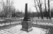
Dekabristov Garden
DEKABRISTOV GARDEN is situated on Dekabristov Island in the area of where it is thought that the graves of five executed Decembrists are located, hence the name. It is situated between Uralskaya Street, Nalichnaya Street and KIMa Avenue
|
|
|
|
|
hidden
|
Dekabristov Island
DEKABRISTOV ISLAND (Island of Decembrists), known as Goloday Island until 1926 in the west of St. Petersburg. It is situated north of Vasilievsky Island and separated from it by the Smolenka River. It is 4
|
|
|
|
|
hidden
|
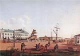
Dekabristov Square
DEKABRISTOV SQUARE (prior to 1925, also called Senatskaya, Petrovskaya), is situated between Admiralteyskaya Embankment and St. Isaac Square. It appeared at the beginning of the 18th century west of the outer bank of Admiralty Fortress;
|
|
|
|
|
hidden
|
Dekabristov Street
DEKABRISTOV STREET, called Ofitserskaya Street until 1918, running from Voznesensky Avenue to Pryazhka River Embankment. The street was laid in the 1740s across the Admiralty Board attendants" living-quarters
|
|
|
|
|
hidden
|
Demidov Garden
DEMIDOV GARDEN is situated at Ofitserskaya (today Dekabristov) Street; between Pisareva Street and Moika River Embankment. In the early 18th century the lot belonged to Baron P.P
|
|
|
|
|
hidden
|
Deviatogo Yanvarya Children Park
DEVIATOGO YANVARYA CHILDREN PARK (20 Stachek Avenue) is located between Shvetsov Street, Marshal Govorov Street, Tikhomirskaya Street and Stachek Avenue. It consists of 10
|
|
|
|
|
hidden
|
Dibuny, area
DIBUNY, an area in the west part of Pesochny municipal unit, on the right bank of the Chernaya River. There is a railway station of the same name. The toponym originates from the Old Russian word "dybun" meaning swamp or bog
|
|
|
|
|
hidden
|
Dobrolyubova Avenue
DOBROLYUBOVA AVENUE, running from Kronverksky Avenue to Bolshoy Avenue of the Petrogradskaya Side. Laid in the 1860s along the route of a filled-in section of the Zhdanovka River
|
|
|
|
|
hidden
|
Dolgoe Lake
DOLGOE LAKE, one of the largest residential areas. Located in the North-West of St. Petersburg, it neighbours Kolomyagi in the east, Commandant's Aerodrome in the southeast and Yuntolovo Forest Estate in the west
|
|
|
|
|
hidden
|
Dolgoye Lake
DOLGOYE LAKE (Long Lake) is located in the northern St. Petersburg at the crossing of Olkhovskaya Street and Koroleva Avenue. Before the 18th century, it was named Pitkyyarvi ("long lake")
|
|
|
|
|
hidden
|
Dostoevskogo Street
DOSTOEVSKOGO STREET, running from Kuznechny Lane to Sotsialisticheskaya Street. In 1739-99, the main part of the street was called Skatertnaya; the length extending from Svechnoy Lane to Ruzovskaya Street bore the name Semenovskaya Street (after the
|
|
|
|
|
hidden
|
Dudergofka, river
DUDERGOFKA (Duderhof, known as Dudorovka in the 18th century), a river in the south-west of St. Petersburg. The name originates from Duderhof Heights. The river emerges from Lake Duderhof (Dudergofskoe)
|
|
|
|
|
hidden
|
Dudergofsky Canal
DUDERHOFSKY CANAL was built during the improvement of the Peterhof Highway and Southern Primorsky Park. It was named after the Duderhofka River (the Canal covers the river's mouth)
|
|
|
|
|
hidden
|
Duderhof Heights
DUDERHOF HEIGHTS a group of hills of glacial origin in the south of St. Petersburg eastwards from Krasnoe Selo and the Ligovo-Gatchina Railway. In the early 18th century they were known as the Duderhof Hills later Duderhof Heights (from Lappish
|
|
|
|
|
hidden
|
Duderhof Lake (Krasnoye Selo)
Duderhof Lake is located in the southern end of Krasnoye Selo (in Mozhaysky and Villosi Villages) at true altitude of 79.9 meters. It has a natural lowering among moraine hills in the centre of Izhora Heights (hence the name Duderhof Heights)
|
|
|
|
|
hidden
|
Dunaysky Avenue
DUNAYSKY AVENUE, running from Predportovaya Street to Sofiyskaya Street, through Srednaya Rogatka and Kupchino. The avenue was named after the Danube River in 1968
|
|
|
|
|