hidden
|
"Marquis's Puddle"
"MARQUIS'S PUDDLE", an ironic local name of the eastern part of the Gulf of Finland between the Neva head and Kotlin Island. The name was coined by Baltic fleet officers in the beginning of the 19th century
|
|
|
|
|
hidden
|
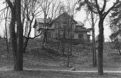
Martynovka
MARTYNOVKA, a locality in the northwest of St. Petersburg northwards from Kolomyagi. In the late 19th to early 20th centuries there was the summer cottage settlement of Grafskaya intersected by a narrow-track railway connecting Novaya Derevnya and
|
|
|
|
|
hidden
|
Martyshkino
MARTYSHKINO, formerly a settlement, in 1997 it was incorporated into the town of Lomonosov and is located westwards from Old Peterhof; also by the railway station along the line Saint Petersburg - Lomonosov
|
|
|
|
|
hidden
|
Maslobuyansky Canal
MASLOBUYANSKY CANAL (the Maslyany (Oil) Canal, the Maslyany Buyan Ditch) was constructed in the southeast Vasilievsky Island in the middle of the 18th century. It was named after the now non-existent Maslyany Buyan
|
|
|
|
|
hidden
|
Matisov Canal
MATISOV CANAL is located in the southwest of St. Petersburg westwards from Yuzhno-Primorsky Park. The canal was excavated in the second half of the 20th century in the left bank lows of Duderhof Canal amidst swampy surrounding of Neva Lowland
|
|
|
|
|
hidden
|
Matisov Island
MATISOV ISLAND situated between the Bolshaya Neva River, Moika River, and Pryazhka River. It is 26 hectares in area, 700 metres long, and 500 metres wide. In the early 18th century, it was called Kalasaari translated as Sloping Island from Finnish
|
|
|
|
|
hidden
|
Matrosskaya Sloboda
MATROSSKAYA SLOBODA (Sailors' Settlement), a settlement founded in the early 18th century on the right bank of the Okhta River, opposite the confluence of the Okhta River and Okkervil River
|
|
|
|
|
hidden
|
Mayakovskogo Street
MAYAKOVSKOGO STREET, between Nevsky Prospect and Kirochnaya Street. It was built in the first half of the 18th century, and was called Srednyaya Pershpektivaya, in the middle of 19th century - Shestilavochnaya Street
|
|
|
|
|
hidden
|
Metallistov Avenue
METALLISTOV AVENUE, between Yakornaya Street and Laboratornaya Street, a large transport thoroughfare that goes through the Bolshaya Okhta River, Rubleviki and Polyustrovo, following the bend of the Neva River
|
|
|
|
|
hidden
|
Metallostroy, settlement
METALLOSTROY, an urban settlement within the Kolpinsky District of Saint Petersburg, and a station along the Oktyabrskaya Railway. As of 2001, the population count was 23,700 inhabitants
|
|
|
|
|
hidden
|
Mikhaila Arkhangela Selo
MIKHAILA ARKHANGELA SELO, the historical name of a locality on the Nevskaya Zastava Territory. In the north it bordered on the settlement of Smolenskoe and in the south by the Farforovaya Colony
|
|
|
|
|
hidden
|
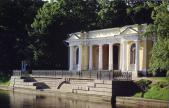
Mikhailovsky Garden
MIKHAILOVSKY GARDEN is a landscape architectural monument from the first third of the 19th century. It is a city garden with an area of 8.7 hectares confined on one side by Mikhailovsky Palace, Griboedova Canal Embankment
|
|
|
|
|
hidden
|
Mikhaylovskaya Street
MIKHAYLOVSKAYA STREET (known as Lassalya Street from 1918 to 1940, then called Brodskogo Street until 1991), between Nevsky Prospect and Iskusstv Square. The street, laid in 1834 after the design plan conceived by architect C.I
|
|
|
|
|
hidden
|
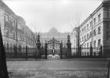
Millionnaya Street
MILLIONNAYA STREET [until 1738 - German settlement, until the middle of the 18th century - Bolshaya Nemetskaya Street, in the 1740-1800s - Bolshaya Millionnaya Street, in 1918-91 - Khalturina Street, after worker-revolutionary S.N
|
|
|
|
|
hidden
|
Mitrofanyevskoe Freeway
MITROFANYEVSKOE FREEWAY (until the 1890s - Bolshaya Mitrofanyevskaya Road), between the square of Baltiisky Railway Station and Yaltinskaya Street, parallel to Varshavskaya Railway Line
|
|
|
|
|
hidden
|
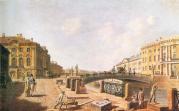
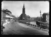
Moika, river
MOIKA (the original name Mya; known as Muya until the early 18th century, derived from the Izhora word for "slush, mire"), a river in the Neva river delta. The Moika River is 4.67 kilometres long, with a width of up to 40 metres
|
|
|
|
|
hidden
|
Mokhovaya Street
MOKHOVAYA STREET (until 1826 - Khamovaya Street or Khamovskaya Street), between Tchaikovskogo Street and Belinskogo Street. It was built up in the settlement of weavers ("khamovnik" - hence the first name)
|
|
|
|
|
hidden
|
Molodezhnoe
MOLODEZHNOE (until 1948 Yammelyeki), formerly a settlement, from 1998 was attributed the status of a municipal formation within Kurortny District of St. Petersburg, and is located in a resort zone on the northern coast of the Gulf of Finland
|
|
|
|
|
hidden
|
Monastyrka, river
MONASTYRKA, a river in the south-east of the central part of St. Petersburg, running from Obvodny Canal to the Neva River. The name originates from the monastery located on its banks, Alexander Nevsky Lavra
|
|
|
|
|
hidden
|
Monastyrsky Island
MONASTYRSKY ISLAND situated between the Neva River, Obvodny Canal and Monastyrka River. It is 50 hectares in area, 900 metres long, and 600 metres wide. The island formed after Obvodny Canal was built in 1832
|
|
|
|
|
hidden
|
Monetnaya Bolshaya Street
MONETNAYA BOLSHAYA STREET, between Kronverkskaya Street and Chapaeva Street. In the second half of the 18th century it was Third Matveevskaya Street (after St. Matthew’s Church)
|
|
|
|
|
hidden
|
Morskaya Bolshaya Street
MORSKAYA BOLSHAYA STREET (in 1920-93 - Herzen Street, after A.I. Herzen), located from the General Staff Arch to Kryukov Canal. It was constructed in the early 18th century, in Morskaya settlement (hence the name)
|
|
|
|
|
hidden
|
Morskaya Embankment
MORSKAYA EMBANKMENT goes along the aggraded shore of the Gulf of Finland from the square in front of the Pribaltiyskaya Hotel to Nalichnaya Street (the name was given in 1972)
|
|
|
|
|
hidden
|
Morskaya Malaya Street
MORSKAYA MALAYA STREET (since 1738 - Bolshaya Lugovaya Street, since the middle of the 18th century until the 1820s - Novaya Isaakievskaya Street, in 1902-93 - Gogolya Street, after N.V. Gogol), between Nevsky Prospect and St. Isaac's Square
|
|
|
|
|
hidden
|
Morskie Dubki, Park (Lisy Nos)
MORSKIE DUBKI is a park at the West end of the village Lisy Nos. It stretches in a strip near the shore of the Gulf of Finland. Its length is approximately 500 metres and its width ranges from 100 to 250 metres
|
|
|
|
|
hidden
|
Morskoy Canal
MORSKOY CANAL (the Naval Canal) was constructed along shallow waters of Neva Bay between Gutuyevsky and Kanonersky Islands in 1874-85. The Canal has materially changed the islands' shape
|
|
|
|
|
hidden
|
Moshkov Lane
MOSHKOV LANE named Zaporozhsky Lane after a Ukrainian city in 1952-89, between Dvortsovaya Embankment and Moika River Embankment. It was laid in the first quarter of the 18th century and named after houseowner and Master of the Household P. I
|
|
|
|
|
hidden
|
Moskovskaya Side
MOSKOVSKAYA Side, the 18th century name of the territory on the left bank of the Neva River to the east and south-east from the Fontanka River, that was populated with labourers, brought from Moscow in the early 18th century (hence the name)
|
|
|
|
|
hidden
|
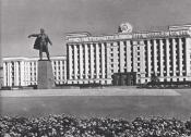
Moskovskaya Square
MOSKOVSKAYA SQUARE, in the south part of Moskovsky Avenue, at its intersection with Leninsky Avenue and Tipanova Street. Occupying the territory of 13 hectares, it is recognised as the largest square in St. Petersburg
|
|
|
|
|
hidden
|
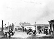
Moskovskaya Zastava
MOSKOVSKAYA ZASTAVA, the historical name of the north part of present-day Moskovsky District. The name originates from the post that existed at the intersection of Moscow road and Ligovsky Canal
|
|
|
|
|