|
|
|
Rubricator
/
/
City Topography
hidden
|
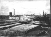
Zastavy (Outposts) (entry)
ZASTAVY (OUTPOSTS), checkpoints, established in the early 18th century on the main roads at the entrance to St. Petersburg to check goods, luggage and to register people, leaving or entering the city
|
|
|
|
|
hidden
|
Zayachy Island
ZAYACHY ISLAND situated in the broadest part of the Neva. In the north, it is separated from Petrogradsky Island with Kronverksky Strait. The island is 28 hectares in area, 900 metres long, and 500 metres wide
|
|
|
|
|
hidden
|
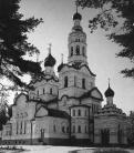
Zelenogorsk town
ZELENOGORSK (until 1948 Terijoki), the former town, since 1998 - a municipal unit forming a part of Kurortny District of St. Petersburg, 46 km to the north-west of the city, in the resort area on the north coast of the Gulf of Finland
|
|
|
|
|
hidden
|
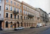
Zhdanovskaya Street and Embankment
ZHDANOVSKAYA EMBANKMENT, running from Bolshoy Avenue of the Petrogradskaya Side to Novoladozhskaya Street. The embankment was formed in the 18th century as a passage along the right bank of the Zhdanovka River
|
|
|
|
|
hidden
|
Zhernovka, locality
ZHERNOVKA, locality in the northern part of St. Petersburg. Its name derived from a former village, known from 1778, which was situated on the left bank of the Zhernovka River (the Lapka) at the place where the Zhernovka converged with the Okhta
|
|
|
|
|
hidden
|
Zhukovskogo Street
ZHUKOVSKOGO STREET, running from Liteiny Avenue to Ligovsky Avenue. Previously known as Malaya Italyanskaya Street, the street assumed its present-day name in 1902 in commemoration of the 50th anniversary of the death of V.A. Zhukovsky
|
|
|
|
|
hidden
|
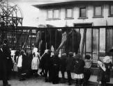
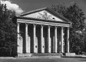
Zoological Park
ZOOLOGICAL PARK (until 1952, the Zoological Garden), a cultural, educational and scientific institution, where wild and certain domestic animals are kept, demonstrated and studied
|
|
|
|
|
|
hidden
|
|
hidden
|
|
hidden
|
|
hidden
|
|
hidden
|
|
hidden
|
|
hidden
|
|
hidden
|
|
hidden
|
|
hidden
|
|
hidden
|
|
hidden
|
|
hidden
|
|
hidden
|
|
hidden
|
|
hidden
|
|
hidden
|
|
hidden
|
|
hidden
|
|
hidden
|
|
hidden
|
|
hidden
|
|
hidden
|
|