hidden
|
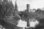
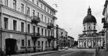
Pavlovsk, town
PAVLOVSK, a town (from 1796), municipal unit, and the centre of the Pavlovsky District on the Slavyanka River. Known as Slutsk in 1918-44. As of 2002, the population count was approximately 16,000 inhabitants
|
|
|
|
|
hidden
|
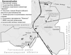
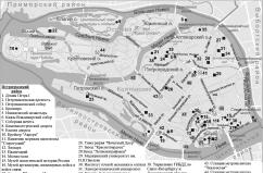
Pavlovsky District
PAVLOVSKY DISTRICT, an administrative and territorial unit of St. Petersburg, with its administration located in the town of Pushkin, at 24 Oktyabrsky Boulevard. It owes its name to the town of Pavlovsk at the district's centre
|
|
|
|
|
hidden
|
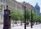
Pedestrian Zones (entry)
PEDESTRIAN ZONES. The first pedestrian zone in St. Petersburg was laid out on Malaya Konyushennaya Street after its reconstruction in 1995-97 (architect F. K. Romanovsky)
|
|
|
|
|
hidden
|
Perinnaya Line
PERINNAYA LINE lying along Bolshoy Gostiny Dvor between Nevsky Prospect and Lomonosova Street. In the mid-to-late 19th century, it was known as Surovskaya, or Bolshaya Surovskaya, Line (Textile Line) so named because of the goods sold in the line
|
|
|
|
|
hidden
|
Peski
PESKI (sands), the historical name of the area in the centre of St. Petersburg, between the Neva River, Nevsky Prospect and Ligovsky Avenue, on both sides of Suvorovsky Avenue. The name is caused by the nature of the ground
|
|
|
|
|
hidden
|
Pesochnaya Embankment
PESOCHNAYA EMBANKMENT situated on Aptekarsky Island between Kamennoostrovsky Avenue and Karpovka River Embankment. It was laid on the left bank of the Malaya Nevka River in 1820s and named Pesochnaya Embankment (Sand Embankment) because of the sandy
|
|
|
|
|
hidden
|
Pesochny, settlement
PESOCHNY, a former settlement, since 1998, a municipal unit within the Kurortny District of Saint Petersburg; 23 kilometres northwest of the city centre; on the Chernaya River, 7 kilometres away from its inflow into Lake Sestroretsky Razliv
|
|
|
|
|
hidden
|
Pestelya Street
PESTELYA STREET known as Panteleimonovskaya Street until 1923, between Fontanka River Embankment and Radishcheva Square. The street was named after P. I. Pestel
|
|
|
|
|
hidden
|
Petergofskaya Road
PETERGOFSKAYA ROAD (Petergofskaya Pershpektiva), name of Narvskaya Road between St. Petersburg and Peterhof in the 18th century. The road ran along the southern coast of the Gulf of Finland in place of the present-day Staro-Petergofsky Avenue
|
|
|
|
|
hidden
|
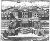
Peterhof, palace and park ensemble
PETERHOF, the palace and park ensemble in Petrodvorets. Until 1917, remained a summer imperial residence on the southern coast of the Gulf of Finland. The construction of Peterhof started in 1709 at the command of Tsar Peter the Great
|
|
|
|
|
hidden
|
Petro-Slavyanka
PETRO-SLAVYANKA, a municipal unit within the Kolpinsky District, on the Slavyanka River, at the Kuzminka River inflow; also a train station along the Saint Petersburg - Moscow line. As of 2001, the population totalled 1,200 people
|
|
|
|
|
hidden
|
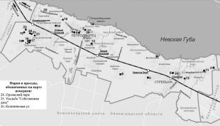
Petrodvorets, town
PETRODVORETS (until 1944 Peterhof), a town, centre of the Petrodvoretsky District, 28 kilometres southwest of Saint Petersburg; a harbour on the southern coast of the Gulf of Finland; name of a railway station (Novy Peterhof)
|
|
|
|
|
hidden
|
Petrodvortsovy District
PETRODVORTSOVY DISTRICT, an administrative-territorial entity within St. Petersburg, with the territorial administration located at 7 Kalininskaya Street, Petrodvorets. The district is named after the town of Petrodvorets, the district centre
|
|
|
|
|
hidden
|
Petrograd
PETROGRAD, official name of St. Petersburg since 18 August 1914, chosen after Russia entered the First World War of 1914-18; it replaced the German name St. Petersburg
|
|
|
|
|
hidden
|
Petrogradskaya Embankment
PETROGRADSKAYA EMBANKMENT known as Peterburgskaya Embankment until 1914. It lies between Petrovskaya Embankment and Karpovka River Embankment on the left bank of the Neva River in the east of Petrogradsky Island (hence the name)
|
|
|
|
|
hidden
|
Petrogradskaya Side
PETROGRADSKAYA SIDE (in the 18th century - Gorodskaya Side, until 1914 - Peterburgskaya Side), the joint name of the territory that includes the following islands: Petrogradsky, Aptekarsky, Petrovsky and Zayachy
|
|
|
|
|
hidden
|
Petrogradsky District
PETROGRADSKY DISTRICT, an administrative and territorial unit of St. Petersburg, with its administration located at 19 Bolshaya Monetnaya Street. The district was formed in 1917, and in 1936 the Primorsky District was separated from its territory
|
|
|
|
|
hidden
|
Petrogradsky Island
PETROGRADSKY ISLAND situated between the Neva River, Kronverksky Strait, Malaya Neva River, Zhdanovka River, Malaya Nevka River, Karpovka River, and Bolshaya Nevka River. It is 635 hectares in area, 4.2 kilometres long, and 2.5 kilometres wide
|
|
|
|
|
hidden
|
Petropol
PETROPOL (from Ancient Greek Petropolis, the city of Peter), the name attached to St. Petersburg and St. Peter and Paul Fortress and used in restricted contexts until the designation St. Petersburg was assigned to the city
|
|
|
|
|
hidden
|
Petrovskaya Embankment
PETROVSKAYA EMBANKMENT lying between Troitskaya Square and Petrogradskaya Embankment on the right bank of the Neva River on Petrogradskaya Side. It appeared in what was then the city centre in the 1700s as the first embankment of St. Petersburg
|
|
|
|
|
hidden
|
Petrovsky Island
PETROVSKY ISLAND situated between the Malaya Neva River, Malaya Nevka River, and Zhdanovka River separating it from Petrogradsky Island. It is 120 hectares in area, three kilometres long, and 600 metres wide
|
|
|
|
|
hidden
|
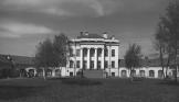
Petrovsky Park
PETROVSKY PARK is located on Petrovsky Island, along the left bank of the Zhdanovka River. It is surrounded with Petrovsky Avenue. Landscape planning of the present-day park (the total area is approximately 6
|
|
|
|
|
hidden
|
Petrovsky Pond
PETROVSKY POND is located in the south-east of Petrovsky Island in Petrovsky Park. It is a recreational zone, 350 meters long and 150 meters wide.
Y. P. Seliverstov
|
|
|
|
|
hidden
|
Pionerskaya Square
PIONERSKAYA SQUARE between Zagorodny Avenue and the Young People's Theatre. It partly occupies the former vast ground of Semenovsky Lifeguard Regiment. Members of Petrashevsky's Circle were subjected to a mock execution in the ground in 1849 and
|
|
|
|
|
hidden
|
Pionersky Park
PIONERSKY PARK is located in Piskarevka District, between Mechnikova Avenue, Piskarevsky Avenue and Bestuzhevskaya Street. The total area of the park is 12.4 hectares, including seven hectares of lawn. It was laid out in 1968
|
|
|
|
|
hidden
|
Pirogovskaya Embankment
PIROGOVSKAYA EMBANKMENT on the right bank of the Bolshaya Nevka River between Akademika Lebedeva Street and Maly Sampsonievsky Avenue. It consists of two sections. The first section, named after N. I
|
|
|
|
|
hidden
|
Pisareva Street
PISAREVA STREET known as Shafirovskaya Street from the mid-19th century and named Alexeevskaya Street after Grand Prince Alexey Alexeevich in 1887-1923 who had a palace at 122 Moika River Embankment
|
|
|
|
|
hidden
|
Piskarevka
PISKAREVKA, an area to the north-east of St. Petersburg, to the north of Marshal Blucher Avenue and to the west of the railway junction line. It remained a neglected ground up to the beginning of the 19th century
|
|
|
|
|
hidden
|
Piskarevsky Avenue
PISKAREVSKY AVENUE between Sverdlovskaya Embankment and the upper Okhta River near Novaya Village. It crosses Polyustrovo, Piskarevka (hence the name), and Ruchi
|
|
|
|
|
hidden
|
Piskarevsky Forest Park
PISKAREVSKY FOREST PARK is located between Butlerova Street, Vernosti Street, Amurskaya Street and Nepokorennykh Avenue. The total area of the park is 116 hectares. The forest park was laid out in 1962 on the basis of a natural forest
|
|
|
|
|