Authors
/
hidden
|
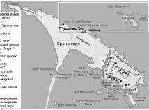
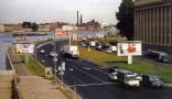
Kronstadtsky District
KRONSTADTSKY DISTRICT is an administrative territorial unit of St. Petersburg (Its territory administration is located at 36 Lenina Avenue,.) Formed in 1998, it was named after the city of Kronstadt, which is the district centre
|
|
|
|
|
hidden
|
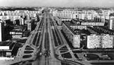
Kupchino
KUPCHINO, a region of large scale residential housing in the south of St. Petersburg; it is confined in the north by Fuchika Street, in the east by the Moskovskaya Line of Oktyabrskaya Railway, in the west by a line of Vitebskaya Railway
|
|
|
|
|
hidden
|
Kurort, locality
KURORT, a locality north of the town of Sestroretsk, between the coast of the Gulf of Finland and the Malaya Sestra River, along the Saint Petersburg - Sestroretsk - Beloostrov railway line
|
|
|
|
|
hidden
|
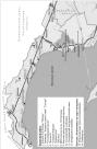
Kurortny District
KURORTNY DISTRICT is an administrative territorial unit of St. Petersburg (Its territory administration is located at 1 Svobody Square) Formed in 1946, the district stretches in a narrow line along the northern coast of the Gulf of Finland for over
|
|
|
|
|
hidden
|
Kushelevka, area
KUSHELEVKA, an area in Vyborgskaya Side, between Karbysheva Street, Nepokorennykh Avenue, Bogoslovskoe Cemetery and Polyustrovsky Avenue. In 1781, Empress Catherine II granted 746 desyatin of land "in Vyborgskaya Side between Pargolova Dacha
|
|
|
|
|
hidden
|
Lavrov S.B. (1928 - 2000), geographer
LAVROV Sergey Borisovich (1928, Leningrad - 2000, St. Petersburg), geographer, received a Ph.D. (geography) in 1968 and Honoured Worker of Science of the Russian Federation in 1998
|
|
|
|
|
hidden
|
Lesnoy
LESNOY, a historical district in the north of St. Petersburg, between Engelsa Avenue to the west, Manchesterskaya Street to the north, Thoreza Avenue and Karbysheva Street to the east and Novorossiiskaya Street to the south
|
|
|
|
|
hidden
|
Levashovo, settlement
LEVASHOVO, a former settlement, north-west of the city centre; since 1997, a municipal unit of the Vyborgsky District of Saint Petersburg. It emerged as a settlement for workers building the Vyborg railway station in 1870
|
|
|
|
|
hidden
|
Levashovskaya Pustosh
LEVASHOVSKAYA PUSTOSH, a tract of land in the vicinity of the Levashovo Railway Station (135 Gorskoe Highway), one of the cemeteries for political victims born in Leningrad
|
|
|
|
|
hidden
|
Ligovo, village
LIGOVO, a historical district in the south-west of St. Petersburg, between Peterhofskoye Highway, Marshala Zhukova Avenue, Baltiiskaya Railway Line and the Ivanovka River
|
|
|
|
|
hidden
|
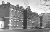
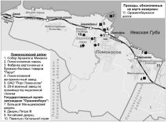
Lomonosov, town
LOMONOSOV (until 1948 Oranienbaum), a town and municipal unit within Saint Petersburg, the centre of Lomonosovsky District of the Leningrad Region, located 32 kilometres southwest of the city centre on the southern coast of the Gulf of Finland
|
|
|
|
|
hidden
|
Lomonosovsky District
LOMONOSOVSKY DISTRICT, an administrative and territorial unit of St. Petersburg, with its administration located in the town of Lomonosov, at 42 Dvortsovy Avenue
|
|
|
|
|
hidden
|
Malaya Okhta, locality
MALAYA OKHTA, a locality in the eastern part of St. Petersburg, situated on the left bank of the Neva River, above the mouth of the Okhta River. It borders on Soedinitelnaya Railway Line in the north and the Okkervil River in the north-east
|
|
|
|
|
hidden
|
Malinovka
MALINOVKA, formerly a village, located in the northeast of St. Petersburg; known from the late 18th century. It stretched at the place where two rivers of the same name converge (sometimes called Narvin Brook) and the Okhta River (at the
|
|
|
|
|
hidden
|
Martynovka
MARTYNOVKA, a locality in the northwest of St. Petersburg northwards from Kolomyagi. In the late 19th to early 20th centuries there was the summer cottage settlement of Grafskaya intersected by a narrow-track railway connecting Novaya Derevnya and
|
|
|
|
|
hidden
|
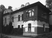
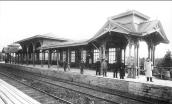
Martyshkino
MARTYSHKINO, formerly a settlement, in 1997 it was incorporated into the town of Lomonosov and is located westwards from Old Peterhof; also by the railway station along the line Saint Petersburg - Lomonosov
|
|
|
|
|
hidden
|
Matisov Island
MATISOV ISLAND situated between the Bolshaya Neva River, Moika River, and Pryazhka River. It is 26 hectares in area, 700 metres long, and 500 metres wide. In the early 18th century, it was called Kalasaari translated as Sloping Island from Finnish
|
|
|
|
|
hidden
|
Matrosskaya Sloboda
MATROSSKAYA SLOBODA (Sailors' Settlement), a settlement founded in the early 18th century on the right bank of the Okhta River, opposite the confluence of the Okhta River and Okkervil River
|
|
|
|
|
hidden
|
Mikhaila Arkhangela Selo
MIKHAILA ARKHANGELA SELO, the historical name of a locality on the Nevskaya Zastava Territory. In the north it bordered on the settlement of Smolenskoe and in the south by the Farforovaya Colony
|
|
|
|
|
hidden
|
Molodezhnoe
MOLODEZHNOE (until 1948 Yammelyeki), formerly a settlement, from 1998 was attributed the status of a municipal formation within Kurortny District of St. Petersburg, and is located in a resort zone on the northern coast of the Gulf of Finland
|
|
|
|
|
hidden
|
Monastyrsky Island
MONASTYRSKY ISLAND situated between the Neva River, Obvodny Canal and Monastyrka River. It is 50 hectares in area, 900 metres long, and 600 metres wide. The island formed after Obvodny Canal was built in 1832
|
|
|
|
|
hidden
|
Moskovskaya Side
MOSKOVSKAYA Side, the 18th century name of the territory on the left bank of the Neva River to the east and south-east from the Fontanka River, that was populated with labourers, brought from Moscow in the early 18th century (hence the name)
|
|
|
|
|
hidden
|
Moskovskaya Zastava
MOSKOVSKAYA ZASTAVA, the historical name of the north part of present-day Moskovsky District. The name originates from the post that existed at the intersection of Moscow road and Ligovsky Canal
|
|
|
|
|
hidden
|
Moskovsky District
MOSKOVSKY DISTRICT is an administrative territorial unit of St. Petersburg. (Its territory administration is located at 129 Moskovsky Avenue) It was founded in 1919, and its present-day borders were established in 1965
|
|
|
|
|
hidden
|
Mozhaysky, settlement
MOZHAYSKY, a former urban settlement, known as Duderhof until 1950; incorporated in 1973 into the Krasnoselsky District of Leningrad. Located 30 kilometres southwest of the city centre
|
|
|
|
|
hidden
|
Municipal Districts
MUNICIPAL DISTRICTS, administrative units in the structure of city districts of St. Petersburg (see Administrative division), were formed in 1997, they are governed by elected municipal councils
|
|
|
|
|
hidden
|
Murino
MURINO, a rural settlement (and former village) on Toksovskoe Freeway, 0.5 km from the city borders, adjoining the north-east outskirts of St. Petersburg. The Murinsky Stream, railway station in St
|
|
|
|
|
hidden
|
Murzinka
MURZINKA, a river in the north-east of St. Petersburg. In the 1720s, it was named after a country house of the same name. The length is about five kilometres, the width varies from one to three kilometres, at its mouth up
|
|
|
|
|
hidden
|
Narvskaya Zastava
NARVSKAYA ZASTAVA, the historical name of the northern part of Kirovsky District. It descends to an outpost on the post road to Narva and Reval (today Tallin), that was located on the place of present-day Stachek Square
|
|
|
|
|
hidden
|
Nevskaya Zastava
NEVSKAYA ZASTAVA (outpost), a historical name of the territory along the left bank of the Neva River from Alexander Nevsky Lavra to Rybatskoe. It encompasses the following historical districts and localities: Steklyanny Settlement (Glass Settlement)
|
|
|
|
|