Addresses
/
Kamennoostrovsky Ave/Saint Petersburg, city
hidden
|
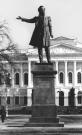
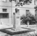
Alexander Pushkin, Monuments to (entry)
ALEXANDER PUSHKIN, MONUMENTS TO. In 1881 a temporary plaster bust of Pushkin (from a model by the sculptor I. P. Vitali) was installed in the park at Pushkinskaya Street
|
|
|
|
|
hidden
|
Anikushin M.K., (1917-1997), sculptor
ANIKUSHIN Mikhail Konstantinovich (1917, St. Petersburg-1997). Full member of the Academy of Arts of the USSR, People's Artist of the USSR (1963), chairman of the management board for Leningrad Department of the Union of Artists (1962-72, 1986-90)
|
|
|
|
|
hidden
|
Bolshoy Avenue of Petrogradskaya Side
BOLSHOY AVENUE OF PETROGRADSKAYA SIDE, in the 18th century - Bolshaya Road, Bolshaya Garnizonnaya Road, Bolshaya Ofitserskaya Street, in 1919-44 - K. Libknekhta Avenue. It lies between Dobrolyubova Avenue and Karpovka River Embankment
|
|
|
|
|
hidden
|
Concert Halls (entry)
CONCERT HALLS appeared in St. Petersburg in the late 18th century. Earlier, musicians arranged paid concerts in palaces of grandees, theatres, and taverns. The first documented series of public concerts refers to the concerts given by G
|
|
|
|
|
hidden
|
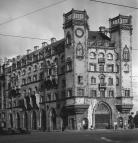
Kamennoostrovsky Avenue
KAMENNOOSTROVSKY AVENUE, located between Troitskaya Square and the Bolshaya Nevka River Embankment. The main thoroughfare joining the city centre and the Petrogradskaya Side with Aptekarsky Island and Kamenny Island
|
|
|
|
|
hidden
|
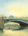
Kamennoostrovsky Bridge
KAMENNOOSTROVSKY BRIDGE (commonly referred to as Betankurovsky), over the Malaya Nevka River, links Aptekarsky and Kamenny Islands along the Kamennoostrovsky Avenue. In 1760 St. Petersburg's fourth boat bridge was built here (architect А. Wist)
|
|
|
|
|
hidden
|
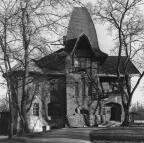
Kamenny Island, ensemble
KAMENNY ISLAND (in 1920-89 - Trudyashchikhsya Island), in the north-west part of the Neva river delta, located between the Bolshaya Nevka River to the north and the Malaya Nevka River to the south, the Krestovka River lies to the east
|
|
|
|
|
hidden
|
Khlopin Radium Institute
KHLOPIN RADIUM INSTITUTE, located at 28 Second Murinsky Avenue, was established in 1921 by the scientist V. I. Vernadsky to study and make practical use of radioactivity
|
|
|
|
|
hidden
|
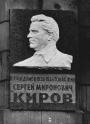
Kirov S.M. the 1st secretary of the regional party committee in 1926-34
KIROV (born Kostrikov) Sergey Mironovich (1886-1934, Leningrad), statesman and party worker. He graduated from Kazan Elementary Mechanical-technical School (1904)
|
|
|
|
|
hidden
|
Kronverksky Avenue
KRONVERKSKY AVENUE, between Troitskaya Square and Mytninskaya Embankment, on the Petrogradskaya Side; its semicircular arch includes the territory of Alexandrovsky Park. The avenue was constructed in the first half of the 18th century
|
|
|
|
|
hidden
|
Leo Tolstoy Square
LEO TOLSTOY SQUARE, at the intersection of Bolshoy Avenue of Petrogradskaya Side and Kamennoostrovsky Avenue. The square was named in the 1920s after the neighbouring street of the same name (since 1798 - Arkhiereiskaya Square
|
|
|
|
|
hidden
|
Maly Avenue of Petrogradskaya Side
MALY AVENUE Of PETROGRADSKAYA SIDE [in the 1770s - Malaya Perspektiva, in 1941-91 - Shchorsa Avenue, after N.A. Shchors a participant of the Civil War (1895-1919)], from Zhdanovskaya Embankment to Shevchenko Square and Kamennoostrovsky Avenue
|
|
|
|
|
hidden
|
Pesochnaya Embankment
PESOCHNAYA EMBANKMENT situated on Aptekarsky Island between Kamennoostrovsky Avenue and Karpovka River Embankment. It was laid on the left bank of the Malaya Nevka River in 1820s and named Pesochnaya Embankment (Sand Embankment) because of the sandy
|
|
|
|
|
hidden
|
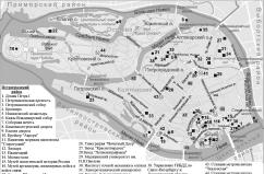
Petrogradskaya Side
PETROGRADSKAYA SIDE (in the 18th century - Gorodskaya Side, until 1914 - Peterburgskaya Side), the joint name of the territory that includes the following islands: Petrogradsky, Aptekarsky, Petrovsky and Zayachy
|
|
|
|
|
hidden
|
Petrogradsky District
PETROGRADSKY DISTRICT, an administrative and territorial unit of St. Petersburg, with its administration located at 19 Bolshaya Monetnaya Street. The district was formed in 1917, and in 1936 the Primorsky District was separated from its territory
|
|
|
|
|
hidden
|
Petrogradsky Island
PETROGRADSKY ISLAND situated between the Neva River, Kronverksky Strait, Malaya Neva River, Zhdanovka River, Malaya Nevka River, Karpovka River, and Bolshaya Nevka River. It is 635 hectares in area, 4.2 kilometres long, and 2.5 kilometres wide
|
|
|
|
|
hidden
|
Popov A.S., (1859-1905), physicist
POPOV Alexander Stepanovich (1859-1905, St. Petersburg), physicist and electrical engineer. He graduated from the University of St. Petersburg in 1882. From 1883 to 1900, he taught at various military educational institutions of Kronstadt and St
|
|
|
|
|
hidden
|
Posadskaya Malaya Street
POSADSKAYA MALAYA STREET, on Petrogradskaya Side, between Kamennoostrovsky Avenue and Chapaeva Street. The road appeared in the 1720s in the settlement of craftspeople and tradespeople, transferred to St
|
|
|
|
|
hidden
|
Public Halls (entry)
PUBLIC HALLS, a special premise for informal mass events. The first public hall was arranged in banker A.A. Ral's house (On the Moika River Embankment, beside Red Bridge; not preserved)
|
|
|
|
|
hidden
|
Pushkarskaya Bolshaya Street
PUSHKARSKAYA BOLSHAYA STREET (until 1798 - Malaya Ofitserskaya Street), between Syezzhinskaya Street and Kamennoostrovsky Avenue, on Petrogradskaya Side. The road appeared in the first third of the 18th century
|
|
|
|
|
hidden
|
Tramway
TRAMWAY (borrowed into Russian as the word derived from English tram (carriage) and way), a means of city rail transport. Three kinds of tramways are known: horse-drawn (see Horse-tram)
|
|
|
|
|
hidden
|
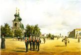
Troitskaya Square
TROITSKAYA SQUARE, called Kommuny Square from 1918 to 1923, then known as Revolyutsii Square until 1991, between Kamennoostrovsky Avenue and Kuybysheva Street. The square appeared in the early 18th century on Gorodskoy (present-day Petrogradsky)
|
|
|
|
|
hidden
|
Troitsky Bridge
TROITSKY BRIDGE (Trinity Bridge; in 1918-34 Ravenstva Bridge, in 1934-99 Kirovsky Bridge), across the Bolshaya Neva River, connecting Suvorova Square with Troitskaya Square (hence, the name) and Kamennoostrovsky Avenue
|
|
|
|
|
hidden
|
Ushakovsky Bridge
USHAKOVSKY BRIDGE (called Stroganovsky until 1952, from the neighboring summer residence of Count A.S. Stroganov; prior to that, Second Kamennoostrovksy), across the Bolshaya Nevka River
|
|
|
|
|
|
hidden
|
|
hidden
|
|
hidden
|
|
hidden
|