|
|
|
hidden
|
General Plans for the Development of Petersburg-Leningrad
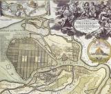
GENERAL PLANS FOR THE DEVELOPMENT OF PETERSBURG-LENINGRAD. One the first projects of St. Petersburg planning dates back to 1709-12. According to it, the city centre should be situated at Kotlin Island and was to be connected to outer parts of the
|
|
|
|
|
hidden
|
Maps and Atlases (entry)
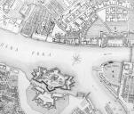
MAPS AND ATLASES. The first known Russian hand-written picture of the Neva River mouth and the territory adjoining the Gulf of Finland dates back to the late 17th century
|
|
|
|
|
|