Authors
/
hidden
|
Pulkovskiye Heights
PULKOVSKIYE HEIGHTS, a natural prominence to the south of St. Petersburg, which received its name from the village of Pulkovo that once existed in the vicinity
|
|
|
|
|
hidden
|
Relief
RELIEF. Despite having a general plain character, its flatness and large built up areas, the relief of St. Petersburg is diverse and full of contrasts. The highest peaks in the southwest of the city reach 176 meters
|
|
|
|
|
hidden
|
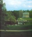
Rumyantsevsky Garden
RUMYANTSEVSKY GARDEN (Solovievsky Garden) is located on Vasilievsky Island, on the right bank of the Bolshaya Neva, between the First and Second lines of Vasilievsky Island. The garden was laid out in 1865-67. It was designed by architect N. N
|
|
|
|
|
hidden
|
Rzhevsky Forest Park
RZHEVSKY FOREST PARK is located in the Eastern outskirts of St. Petersburg, on the boundary of the district of large scale residential developments in Rzhevka-Porokhovye and Vsevolozhsky District of Leningrad Region
|
|
|
|
|
hidden
|
Salnobuyansky Canal
SALNOBUYANSKY CANAL was dug between the Korabelnaya Embankment of the Bolshaya Neva River and the Pryazhka River in 1804. It separated Matisov Island from Kolomensky Island
|
|
|
|
|
hidden
|
Samsonovsky Canal
SAMSONOVSKY CANAL (Samsonovsky Pipeline), an artificial hydraulic construction, a part of the water supply system of Peterhof fountains and ponds. It starts from Bolshoy Krugly Pond of Meadow (Lake) Park and ends in Colonists Park by Olgin Pond
|
|
|
|
|
hidden
|
Schuchye Lake (Komarovo)
SCHUCHIYE LAKE is located in Korelian Isthmus among moraine hills, 3 km to the north of Komarovo village. It is 1.1 km long, about 0.6 km wide and over 5 meters deep. This recreation zone has a lot of health and holiday centres
|
|
|
|
|
hidden
|
Seldyanoy Canal
SELDYANOY CANAL was dug on Gutuyevsky Island from the Ekaterinhofka River in 1827-38 after the catastrophic flood of 1824 (the soil was used to extend the territory). It was 450 meters long with a 200 meters deviation in the middle
|
|
|
|
|
hidden
|
Serebryany Pond
SERBRYANY POND (Silver) was created in 1856 as an element of a landscape park. It is located between Orbeli Street, Malaya Obyezdnaya Street and Institutsky Avenue and stretches parallel to the 2nd Muromsky Avenue
|
|
|
|
|
hidden
|
Sestra, river
SESTRA, a river in the north-west of St. Petersburg, which flows through Sestroretsky District and Kurortny District. The Novgorod Pistsovye Books (Property Registers) of the 15th century record the river as Sestreya (from Finnish word meaning
|
|
|
|
|
hidden
|
Sestroretsky Razliv, lake
SESTRORETSKY RAZLIV is an artificial reservoir in the region of the city of Sestroretsk. It was built during the construction of the armory (see Sestroretsk Toolmaker) by putting up culverts on the Sestra River (hence
|
|
|
|
|
hidden
|
Shkipersky Canal
SHKIPERSKY CANAL, built in the 1720s in the west part of Vasilivsky Island, it was named after skippers' settlement that once existed on this site. The canal joins Galley Harbour and Nevsky Bay (reserved for ship navigation)
|
|
|
|
|
hidden
|
Slavyanka, river
SLAVYANKA, a river in the south-east of St. Petersburg, a left tributary of the Neva River, which flows into the latter 27 kilometres above the mouth of the Neva
|
|
|
|
|
hidden
|
Soils
SOILS, topsoils and subsoils have retained their original composition outside city residential areas, and partly transformed in the city's gardens and parks. The soil cover of St
|
|
|
|
|
hidden
|
Srednaya Nevka
SREDNYAYA NEVKA, branch in the Neva river delta. It comes off the Bolshaya Nevka between Elagin Island and Kamenny Island, separating them from each other and from Krestovsky Island as well
|
|
|
|
|
hidden
|
Starozhilovka, river
STAROZHILOVKA, a river in the north of St. Petersburg, in the area of Shuvalovo and Pargolovo. The river draws its water from the southern slope of the Pargolovo Hills and flows into Lake Nizhnee Bolshoe Suzdalskoe
|
|
|
|
|
hidden
|
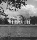
Stroganovsky Garden
STROGANOVSKY GARDEN is located between Ushakovskaya Embankment and Chernaya Rechka River, near the inflow to the Bolshaya Nevka River. The garden was laid out at the end of the 18th century in the estate of Count A. S. Stroganov, hence the name
|
|
|
|
|
hidden
|
Suzdalsky Lakes
SUZDALSKY LAKES include three meridional reservoirs in the northern St. Petersburg, Shuvalovo and Ozerki. They received their name from Suzdal settlement once existing in this area
|
|
|
|
|
hidden
|
Tarakanovka, river
TARAKANOVKA, a river in the west of St. Petersburg, a tributary to the Ekaterinhofka River. Its original name was Metalovka, probably after the iron foundry situated on its bank
|
|
|
|
|
hidden
|
Tentelevka, river (Olkhovka)
TENTELEVKA (Olkhovka), a river in the west of St. Petersburg in the area of Nevskaya Zastava, formerly a tributary to the Tarakanovka River. It was named after the village of Tentelevo which was situated in this area in the 18th century; the other
|
|
|
|
|
hidden
|
Three Hundred Anniversary of St. Petersburg Memorial Park
THREE HUNDRED ANNIVERSARY OF ST. PETERSBURG MEMORIAL PARK was laid out in the 1990s in the north-western outskirts of St. Petersburg, in the western part of Staraya Derevnya
|
|
|
|
|
hidden
|
Ugolnaya Harbour
UGOLNAYA HARBOUR (Coal Harbour) is an artificial harbour located in the south-eastern St. Petersburg. It was constructed in the area of a small arm of Neva Bay for unloading of vessels shipping coal at the turn of the 20th century
|
|
|
|
|
hidden
|
Underground Waters
UNDERGROUND WATERS. St. Petersburg is located in the northwestern part of Moskovsky artesian basin. The water content of the crystalline rocks relate to the residuum and zones where they meet
|
|
|
|
|
hidden
|
Urban Plantations
URBAN PLANTATIONS, artificially created plantations: gardens, parks, forest parks, yards lawns, and the territory around ponds, squares, streets. The plantations perform the double function of sanitary protection and aesthetic city decoration
|
|
|
|
|
hidden
|
Utka, river
UTKA, a river southeast of Saint Petersburg, feeds into the Neva River from the right, meeting it near Heating Station No. 5. Named after manufacturer Utkin, which dates back to the 19th century
|
|
|
|
|
hidden
|
Vasileostrovets, garden
VASILEOSTROVETS, a garden between Bolshoy Avenue and Sredny Avenue of Vasilievsky Island, Klubnaya Street, Twenty-Fourth and Twenty-Fifth Line of Vasilievsky Island. Its area is 1.4 hectares
|
|
|
|
|
hidden
|
Volga-Baltic Waterway
VOLGA-BALTIC WATERWAY, an artificial hydrotechnical structure in the north-west of Russia, linking the basins of the Neva River with those of the Volga and Northern Dvina
|
|
|
|
|
hidden
|
Volkovka, river
VOLKOVKA, a river, formerly the left tributary to the Neva River. It assumed its name in 1887 after the village of Volkovo (see Volkova Village; formerly known as Chernaya Rechka)
|
|
|
|
|
hidden
|
Volkovsky Canal
VOLKOVSKY CANAL, built in the late 1960s during the development of the district of Kupchino along the railway embankment of Vitebskaya Railroad. The canal derives its name from the Volkovka River
|
|
|
|
|
hidden
|
Voronya Mountain
VORONYA MOUNTAIN, a peak to the south of St. Petersburg in the vicinity of Krasnoe Selo village, one of the highest points of the Duderhof Heights (147 meters above the sea level); it overlooks the surroundings with the elevation of approximately
|
|
|
|
|