Authors
/
hidden
|
Glukharka, river
GLUKHARKA, a river in the north-west of St. Petersburg. It used to flow off from the marshes situated west of Dolgoe lake. In the course of the building up of adjacent territory
|
|
|
|
|
hidden
|
Glukhoe Lake
GLUKHOYE LAKE, 1) located between Navalochnaya and Farforovskaya railway stations of the Moscow Line of Oktyabrskaya Railroad. Originally, Glukhoye Lake was 0.8 km long and wide
|
|
|
|
|
hidden
|
Gorely Stream
GORELY, a stream that flows in the north-east of St. Petersburg, near Rzhevka, leading it to be called Rzhevka River on occasion. The stream is a tributary of the Lubya River which forms part of the to the Okhta river basin
|
|
|
|
|
hidden
|
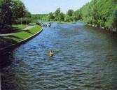
Grebnoy Canal
GREBNOY CANAL (Rowing Canal) is located in the northern part of Krestovsky Island in Primorsky Victory Park at the place of the former Vinnovka River. In 1938, the Grebnoy Canal was projected to be 2 km in length and run from the head of the
|
|
|
|
|
hidden
|
Gulf of Finland
GULF OF FINLAND is the eastern part of the Baltic Sea running deep inland. The northern coast of the Gulf of Finland belongs to Finland; its southern part relates to Estonia and north-western and south eastern coasts are located in Russia
|
|
|
|
|
hidden
|
Gutuyevskaya Harbour
GUTUYEVSKAYA HARBOUR is an artificial rectangular Harbour (600x300 meters, 7 meters deep)located in the northern part of Gutuyev Island (hence the name). After its reconstruction during the building of the Morskoy Canal in 1874-75
|
|
|
|
|
hidden
|
Hero-city Park
HERO-CITY PARK is situated in the south of St. Petersburg, between Pulkovskoe Highway, Moscovskoe Highway and Dunaysky Avenue. It was laid out on the site of orchards and vegetable gardens in 1972-80 and had an area of 25 hectares
|
|
|
|
|
hidden
|
Hydrographic network
HYDROGRAPHIC NETWORK. The hydrographic system of the precincts of St. Petersburg is formed by nearly 20,000 water flows, practically all of them pertaining to the Neva River basin. The total length of the currents exceeds 100,000 kilometres
|
|
|
|
|
hidden
|
Internationalistov Park
INTERNATIONALISTOV PARK is situated in the south part of St. Petersburg, in Kupchino, between Slavy Avenue, Yuzhnoe Freeway, Bukharestskaya Street and Sofiiskaya Street
|
|
|
|
|
hidden
|
Ivanovka, river
IVANOVKA, a river in the south-west of St. Petersburg, in the area of Sosnovaya Polyana and Ligovo. It was named in the 19th century after the village of Ivanovskaya
|
|
|
|
|
hidden
|
Izhora Hills
IZHORA HILLS (Izhora Plateau) the highest western part of the so-called Ordovician Plateau. It received its name form the Izhora people who inhabited the territory. It stretches between the Luga, Oredezh and Tosna River valleys approaching St
|
|
|
|
|
hidden
|
Izhorka Bolshaya, river
IZHORKA BOLSHAYA, a river in the far South-East of Saint Petersburg eastwards from Kolpino. The name derives from the people of Izhora. Raising from the swamps northwards from the settlement of Krasny Bor
|
|
|
|
|
hidden
|
Izmailovsky Garden
IZMAILOVSKY GARDEN is situated in the centre of St. Petersburg, between No 114 and 116а Fontanka River Embankment and Derzhavina Lane. The Polsky Garden is located to the west of the lane. The Izmailovsky Garden is 1.3 hectares in size
|
|
|
|
|
hidden
|
Kamenka, river
KAMENKA, a river in the south-west of St. Petersburg, running from Shuvalovo and Kamenka. It flows from Lake Nizhnee Bolshoe Suzdalskoe and runs through Novo-Orlovsky Forest Park and the pond of Shuvalovsky Pit
|
|
|
|
|
hidden
|
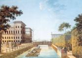
Kamenny Island Canals
KAMENNY ISLAND CANALS were built in the 18-19th centuries and intended to drain the territory, transport construction materials to palaces and estates and lay out park elements. The canal routes were repeatedly changed
|
|
|
|
|
hidden
|
Karelian Isthmus
KARELIAN ISTHMUS, a historic and geographical region between the Gulf of Finland and Ladoga Lake, in the south bounded by the Neva River, in the north - by a datum line linking Vyborg Bay of the Baltic Sea and Lekhmalakhti Bay north-westwards from
|
|
|
|
|
hidden
|
Koltushi Hills
KOLTUSHI HILLS, a height east of St. Petersburg within the boundaries of Neva Lowland. It is a group of kame hills with a height of 60.5 to 78.3 meters above the reclaimed swampy piedmonts at the elevation of 25-35 meters formed along the
|
|
|
|
|
hidden
|
Krasnenkaya, river
KRASNENKAYA, a river in the south-west of St. Petersburg, flowing through Avtovo District and Yugo-Zapad District. The name of the river dates back to 1773, when it was known as Krasnaya Rechka
|
|
|
|
|
hidden
|
Krasny Canal
KRASNY CANAL (Red Canal) was built between the Moika River and the Bolshaya Neva River in 1711 to drain the territory. It passed approximately along the western part of the Field of Mars
|
|
|
|
|
hidden
|
Krestovka, river
KRESTOVKA, a river in the north-west of St. Petersburg, a channel from Malaya Nevka to Srednyaya Nevka. The river separates Kamenny Island and Krestovsky Island. It is 0
|
|
|
|
|
hidden
|
Kronverksky Strait
Kronverksky Strait (Crownwork Strait) is a bow-shaped channel of the Neva River dividing Petrogradsky and Zayachiy Islands. It is over 1 km long, about 50 meters wide and up to 4 meters deep
|
|
|
|
|
hidden
|
Kuzminka, river
KUZMINKA, a river in the south of St. Petersburg between the town of Pushkin and Petroslavyanka. It takes its rise from a swamped lake in Kandakopshino and flows (from the left) into the Slavyanka River upwards from the settlement of Petro-Slavyanka
|
|
|
|
|
hidden
|
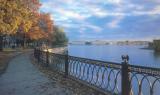
Ladoga Lake
LADOGA LAKE, the largest lake in Europe, is located at the border of Leningrad region and the Republic of Karelia. In the old times, the lake was named Nevo (a Finnish word for "sea"), Ladoga (after the old Russian city Ladoga), and Aldoga
|
|
|
|
|
hidden
|
Lakhtinsky Razliv
LAKHTINSKY RAZLIV (Lakhta High Water) is a lagoon-estuary type lake located on the northern bank of Neva Bay and separated from it with a sand bay-bar which has reinforcing that supports a railway line and a highway
|
|
|
|
|
hidden
|
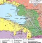
Landscapes
LANDSCAPES. The territory of St. Petersburg and its suburbs display an ample diversity though belonging to the north-west Taiga landscape province of the Russian Plain. There are 13 basic landscape types (or landscape regions)
|
|
|
|
|
hidden
|
Lapka, river
LAPKA, a river in the east of St. Petersburg, in the area of Rzhevka and Porokhovye. Formerly a tributary to the Okhta River, the Lapka used to flow into the Okhta six kilometres above the mouth of the latter, in the area of the village of Malinovka
|
|
|
|
|
hidden
|
Lebyazhy Canal
Lebyazhy Canal (the Swan Canal) was dug from the Bolshaya Neva River to the Moika River between the Field of Mars and Summer Garden in 1711-19. In 1778, the Canal received its name from swans that lived there and in adjacent ponds (in particular
|
|
|
|
|
hidden
|
Lebyazhy Pond
LEBYAZY POND (Swan Pond), an artificial pear-shaped reservoir located in the western part of Krestovsky Island in Primorsky Victory Park. It received its name from swans living in the pond. Its design was finalized in the middle of the 20th century
|
|
|
|
|
hidden
|
Leningrad Region
LENINGRAD REGION, a federal subject of the Russian Federation located in the North-Western Federal District. Formed 1 June 1927, it has existed with its present boundaries since 1945
|
|
|
|
|
hidden
|
Lesnaya Harbour
LESNAYA HARBOUR (Forest Harbour) is a complex of artificial water constructions including several rectangular cuts located in the southern part of Gutuyevsky Island
|
|
|
|
|