Authors
/
hidden
|
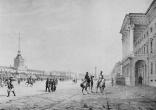
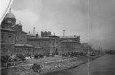
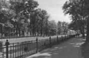
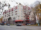
Admiralteisky Avenue
ADMIRALTEISKY AVENUE (Admiralty Avenue) in the mid-to-late 18th century - Admiralteiskaya Street or Bolshaya Street, in 1918-44 - Roshalya Avenue in honour of revolutionary S. G. Roshal (1896-1917). A link between Palace Square and St
|
|
|
|
|
hidden
|
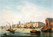
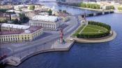
Admiralty Canal
ADMIRALTY CANAL was dug from the eastern ditch of the Amiralty Fortress (today, the Dvortsovy Bridge ramp to the Palace Square) to the Moika River to connect the Admiralty Shipyard with Galerny Dvor (Galley Yard) and warehouses of New Holland
|
|
|
|
|
hidden
|
Angliiskaya Embankment
ANGLIISKAYA EMBANKMENT, from 1738 - Beregovaya Nizhnaya Embankment Street, in the mid-to-late 18th century - Isaakievskaya Embankment, Galernaya Embankment, and Anglinskaya Embankment, from 1800s - Angliiskaya Embankment
|
|
|
|
|
hidden
|
Aptekarsky Lane
APTEKARSKY LANE, translated as Pharmacy Lane, between Millionnaya Street and Moika River Embankment. It was laid in 1730s and called Aptekarskaya Street from the early 1730s to 1780s. The lane was so named after the Central Pharmacy moved from SS
|
|
|
|
|
hidden
|
Arsenalnaya Embankment
ARSENALNAYA EMBANKMENT on the right bank of the Neva River between Arsenalnaya Street and Akademika Lebedeva Street. It was so named in 1887 after Novy Arsenal Plant (today, Arsenal Joint-Stock Company situated in house 1)
|
|
|
|
|
hidden
|
Bakunina Avenue
BAKUNINA AVENUE between Nevsky Prospect and Sinopskaya Embankment. It was laid in the mid-to-late 18th century. Known as Malo-Okhtinsky Ferry Avenue in the late 18th century, it was renamed as Malookhtinsky Avenue in 1820-71
|
|
|
|
|
hidden
|
Barmaleeva Street
BARMALEEVA STREET situated in Petrogradskaya part between Bolshaya Pushkarskaya Street and Chkalovsky Avenue. It was laid in the settlement of St. Petersburg Regiment in 1730s and named after landowner Major Stepan Barmaleev in the late 18th century
|
|
|
|
|
hidden
|
Baskov Lane
BASKOV LANE between Korolenko Street and Fontannaya Street. The street was named after landowner and merchant Baskov in 1800s. The street was laid in the mid-18th century up to the present-day Radishcheva Street and extended up to Fontannaya Street
|
|
|
|
|
hidden
|
Basseinaya Street
BASSEINAYA STREET, translated as Pool Street, between Kubinskaya Street and Vitebsky Avenue. The name originated from a canal (pool) that was then in design. The street is roughly in line with the former Azovskaya Street, Erivanskaya Street
|
|
|
|
|
hidden
|
Birzhevaya Square
BIRZHEVAYA SQUARE, translated as Exchange Square, in 1937-89 - Pushkinskaya Square. The square lies on the spit of Vasilievsky Island between Universitetskaya Embankment and Makarova Embankment
|
|
|
|
|
hidden
|
Bogatyrsky Avenue
BOGATYRSKY AVENUE, a part of the central ring road lying between Kolomyazhsky Avenue and Kamyshovaya Street. The name of Bogatyrsky Avenue and the neighbouring streets is associated with the history of national aviation - the first multi-engine
|
|
|
|
|
hidden
|
Bolotnaya Street
BOLOTNAYA STREET, translated as Swamp Street, between Toreza Avenue and Novorossiiskaya Street. It appeared in swampy area (hence the name) in the early-to-mid 19th century
|
|
|
|
|
hidden
|
Bolshaya Zelenina Street
BOLSHAYA ZELENINA STREET, running from Maly Avenue of Petrogradskaya Side to Admirala Lazareva Embankment. The street was laid in the 1710s as a road leading from the St
|
|
|
|
|
hidden
|
Bolsheokhtinsky Avenue
BOLSHEOKHTINSKY AVENUE, one of the main roads in Bolshaya Okhta lying between Krasnogvardeiskaya Square and Revolyutsii Freeway. It was called Bolshoy Okhtensky Avenue from the 1820s and Bolshe-Okhtensky Avenue from the 1880s to 1956
|
|
|
|
|
hidden
|
Bolshevikov Avenue
BOLSHEVIKOV AVENUE, a part of the central ring road lying between Kollontay Street and Oktyabrskaya Embankment. It was laid in the right-bank part of Nevsky District where names of streets are associated with the history of the revolutionary
|
|
|
|
|
hidden
|
Bolshoy Avenue of Petrogradskaya Side
BOLSHOY AVENUE OF PETROGRADSKAYA SIDE, in the 18th century - Bolshaya Road, Bolshaya Garnizonnaya Road, Bolshaya Ofitserskaya Street, in 1919-44 - K. Libknekhta Avenue. It lies between Dobrolyubova Avenue and Karpovka River Embankment
|
|
|
|
|
hidden
|
Bolshoy Avenue of Vasilievsky Island
BOLSHOY AVENUE OF VASILIEVSKY ISLAND, in 1720s-1780s - Bolshaya Prospektivaya or Bolshaya Pershpektivaya Street, in 1918-22 - F. Adlera Avenue, in 1922-44 - Proletarskoy Pobedy Avenue
|
|
|
|
|
hidden
|
Botkinskaya Street
BOTKINSKAYA STREET, from the late 18th century - Ofitserskaya Street, in 1858-98 - Samarskaya Street. It runs from Lenina Square to Voennykh Medikov Square and Bolshoy Sampsonievsky Avenue
|
|
|
|
|
hidden
|
Chekushi
CHEKUSHI is an area located in the south-western part of Vasilievsky Island. Its name is known from the first part of the 18th century and is related to "chekushi" or "tokmochi"
|
|
|
|
|
hidden
|
Chkalovsky Avenue
CHKALOVSKY AVENUE, between Krasnogo Kursanta Street and Karpovka River Embankment. The avenue was formed in the 18th century out of the length of Porkhovskaya Street, which ran as far as Bolshaya Raznochinnaya Street
|
|
|
|
|
hidden
|
Degtyarny Lane
DEGTYARNY LANE, running from Moiseenko Street to Novgorodskaya Street. Assumed its current name in the 1830s after storehouses containing tar ("degot" in Russian) located nearby. House No
|
|
|
|
|
hidden
|
Dekabristov Island
DEKABRISTOV ISLAND (Island of Decembrists), known as Goloday Island until 1926 in the west of St. Petersburg. It is situated north of Vasilievsky Island and separated from it by the Smolenka River. It is 4
|
|
|
|
|
hidden
|
Dekabristov Street
DEKABRISTOV STREET, called Ofitserskaya Street until 1918, running from Voznesensky Avenue to Pryazhka River Embankment. The street was laid in the 1740s across the Admiralty Board attendants" living-quarters
|
|
|
|
|
hidden
|
Dobrolyubova Avenue
DOBROLYUBOVA AVENUE, running from Kronverksky Avenue to Bolshoy Avenue of the Petrogradskaya Side. Laid in the 1860s along the route of a filled-in section of the Zhdanovka River
|
|
|
|
|
hidden
|
Dostoevskogo Street
DOSTOEVSKOGO STREET, running from Kuznechny Lane to Sotsialisticheskaya Street. In 1739-99, the main part of the street was called Skatertnaya; the length extending from Svechnoy Lane to Ruzovskaya Street bore the name Semenovskaya Street (after the
|
|
|
|
|
hidden
|
Dunaysky Avenue
DUNAYSKY AVENUE, running from Predportovaya Street to Sofiyskaya Street, through Srednaya Rogatka and Kupchino. The avenue was named after the Danube River in 1968
|
|
|
|
|
hidden
|
Dvortsovaya Embankment
DVORTSOVAYA EMBANKMENT (Palace Embankment), called Verkhnaya Naberezhnaya Street or First Verkhnaya Embankment beginning in 1738; in the 1740s-90s, it was known as Millionnaya Embankment; from 1923 to 1944 it was called Devyatogo Yanvarya Embankment
|
|
|
|
|
hidden
|
Dzhambula Lane
DZHAMBULA LANE, running between the Fontanka River Embankment and Zagorodny Avenue. Known as Leshtukov (Lestokov) Lane until 1952. The lane was laid in the first half of the 18th century
|
|
|
|
|
hidden
|
Energetikov Avenue
ENERGETIKOV AVENUE, from Carl Faberge Avenue to Marshala Blucher Avenue. The avenue was laid in the 1960s as a part of the central ring route. It was built during the 1960s-80s
|
|
|
|
|
hidden
|
Engelsa Avenue
ENGELSA AVENUE, a part of Vyborgskoe Freeway until 1918, running from Novosiltsevsky Lane past Third Verkhny Lane; the avenue is an extension of Bolshoy Sampsonievsky Avenue. The avenue was called so in honour of German socialist F. Engels (1820-95)
|
|
|
|
|