Addresses
/
Pesochnaya Embankment/Saint Petersburg, city
hidden
|
Pesochnaya Embankment
PESOCHNAYA EMBANKMENT situated on Aptekarsky Island between Kamennoostrovsky Avenue and Karpovka River Embankment. It was laid on the left bank of the Malaya Nevka River in 1820s and named Pesochnaya Embankment (Sand Embankment) because of the sandy
|
|
|
|
|
hidden
|
Petrogradskaya Side
PETROGRADSKAYA SIDE (in the 18th century - Gorodskaya Side, until 1914 - Peterburgskaya Side), the joint name of the territory that includes the following islands: Petrogradsky, Aptekarsky, Petrovsky and Zayachy
|
|
|
|
|
hidden
|
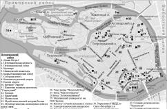
Petrogradsky District
PETROGRADSKY DISTRICT, an administrative and territorial unit of St. Petersburg, with its administration located at 19 Bolshaya Monetnaya Street. The district was formed in 1917, and in 1936 the Primorsky District was separated from its territory
|
|
|
|
|
hidden
|
Professora Popova Street
PROFESSORA POPOVA STREET (in the 1810s - Pesochny Avenue, from the middle of the 19th century to 1940 - Pesochnaya Street), between Aptekarskaya Embankment and Pesochnaya Embankment, on Aptekarsky Island
|
|
|
|
|
hidden
|
Toponymy of St. Petersburg
TOPONYMY OF ST. PETERSBURG, a corpus of names of geographical points situated on the territory of St. Petersburg. Names of rivers, islands, and villages located on the city's future territory appeared long before its foundation
|
|
|
|
|
hidden
|
Vyazemsky Garden
VYAZEMSKY GARDEN is situated on the Aptekarsky Island, on the left bank of Malaya Nevka River, at the corner of Pesochnaya Embankment and Vyazemsky Lane. It was laid out in the first half of the 19th century around Princes Vyazemsky estate (hence
|
|
|
|
|