hidden
|
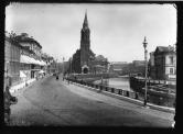
Lanskoe Freeway
LANSKOE FREEWAY (in 1830-1850s, known as Lanskoy Avenue and Road; in 1962-91, known as Smirnova Avenue), running between the Chernaya Rechka Embankment and Engelsa Avenue
|
|
|
|
|
hidden
|
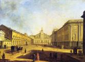
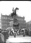
Lenina Square
LENINA SQUARE, at the intersection of Arsenalnaya Embankment and Botkinskaya Street. Named in 1924 in memory of V.I. Lenin's visit to Petrograd in April 1917; known as Lenina Alley until 1946
|
|
|
|
|
hidden
|
Lenina Street
LENINA STREET, running between Sytninskaya Street and Levashovsky Avenue, on the Petrogradskaya Side. Known as Shirokaya Street until 1923. In 1956, it included the former Y. Kalinina Street (until 1923, Matveevskaya Street)
|
|
|
|
|
hidden
|
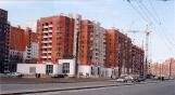
Leninsky Avenue
LENINSKY AVENUE, running between Doblesti Street and Moskovskaya Square, part of the Central Circular Highway. It connects Yugo-Zapad and Ulyanka settlement, and Dachny and Moskovsky Avenues. The avenue, named in 1977 after V.I
|
|
|
|
|
hidden
|
Leo Tolstoy Square
LEO TOLSTOY SQUARE, at the intersection of Bolshoy Avenue of Petrogradskaya Side and Kamennoostrovsky Avenue. The square was named in the 1920s after the neighbouring street of the same name (since 1798 - Arkhiereiskaya Square
|
|
|
|
|
hidden
|
Lermontovsky Avenue
LERMONTOVSKY AVENUE, running between Dekabristov Street and Obvodny Canal Embankment. Formed in 1912 as part of the joining of Bolshaya Masterskaya Street (from Dekabristov Street to Griboedova Canal)
|
|
|
|
|
hidden
|
Lesnoy Avenue
LESNOY AVENUE, from Akademika Lebedeva Street to Institutsky Lane, joining the Finlyandsky Railway Station with the Lesnoy District. The street was laid in the 19th century; until 1913, the avenue
|
|
|
|
|
hidden
|
Lieutenant Schmidt Embankment
LIEUTENANT SCHMIDT EMBANKMENT (until 1887, the Bolshaya Neva Embankment; until 1918, the Nikolaevskaya Embankment), on the right bank of the Bolshaya Neva River, between Seventh Line and Twenty Third Line of Vasilievsky Island. Named after P.P
|
|
|
|
|
hidden
|
Ligovsky Avenue
IGOVSKY AVENUE, running between Nekrasova Street and Moskovsky Avenue. Known as Ligovskaya Street until 1956. Constructed along the Ligovsky Canal track (hence the name) starting in 1891
|
|
|
|
|
hidden
|
Lines of Vasilievsky Island (entry)
LINES Of VASILIEVSKY ISLAND, the historical name of a number of parallel streets that intersect Vasilievsky Island from the south to the north: First to Twenty-Ninth Lines, Birzhevaya Line, Kozhevennaya Line, Kosaya Line, Mendeleevskaya Line
|
|
|
|
|
hidden
|
Liteiny Avenue
LITEINY AVENUE [in 1918-44 - Volodarskogo Avenue, after revolutionary V. Volodarsky (1891-1918)], between Liteiny Bridge and Nevsky Prospect. In 1711, a foundry was founded at the beginning of future Liteiny Avenue; later, houses of craftsmen
|
|
|
|
|
hidden
|
Lomonosova Square
LOMONOSOVA SQUARE (until 1948 - Chernysheva Square), between Zodchego Rossi Street and Fontanka River Embankment. It was named after M.V. Lomonosov (the first name was given after Count I.G. Chernyshev). The road was built in 1828
|
|
|
|
|
hidden
|
Lomonosova Street
LOMONOSOVA STREET, from Griboedova Canal Embankment to "Five Corners". The street was constructed in the first third of the 18th century. Since 1739, the lot before the Fontanka River was called Chernyshev Lane (after the manor of Count I.G
|
|
|
|
|
hidden
|
Makarova Embankment
MAKAROVA EMBANKMENT (until 1887 - Malaya Neva River Embankment, until 1952 - Tuchkova Embankment), between Birzhevaya Square and Smolenka River Embankment, on Vasilievsky Island, on the left bank of the Malaya Neva. The embankment was named after S
|
|
|
|
|
hidden
|
Malaya Konyushennaya Street
MALAYA KONYUSHENNAYA STREET (in the 18th century Rozhdestvenskaya Street, in 1918-91 Sofia Perovskaya Street), located between Nevsky Prospect and Shvedsky Lane, laid out in the 1760s as a passageway to the Court Stables (hence the name)
|
|
|
|
|
hidden
|
Maly Avenue of Petrogradskaya Side
MALY AVENUE Of PETROGRADSKAYA SIDE [in the 1770s - Malaya Perspektiva, in 1941-91 - Shchorsa Avenue, after N.A. Shchors a participant of the Civil War (1895-1919)], from Zhdanovskaya Embankment to Shevchenko Square and Kamennoostrovsky Avenue
|
|
|
|
|
hidden
|
Maly Avenue of Vasilievsky Island
MALY AVENUE Of VASILIEVSKY ISLAND [in the 1730-70s - Third Prospektivaya Street, in the 1780-1800s - Malaya Prospektiva, in 1939-44 - Zheleznyakova Avenue, after the participant of October Revolution and Civil War A.G
|
|
|
|
|
hidden
|
Manezhnaya Square
MANEZHNAYA SQUARE, at the intersection of Italyanskaya Street and Karavannaya Street. It was named in 1866 after the building of Mikhailovsky Manege (1798-1800, architect V.F. Brenna; 1823-24, architect C.I. Rossi )
|
|
|
|
|
hidden
|
Marata Street
MARATA STREET (in the 18th century - Preobrazhenskaya Polkovaya Street, in the first half of the 19th century - Gryaznaya Street, in 1855-1918 - Nikolaevskaya Street after Emperor Nicholas I), between Nevsky Prospect and Podiezdnoy Lane
|
|
|
|
|
hidden
|
Mayakovskogo Street
MAYAKOVSKOGO STREET, between Nevsky Prospect and Kirochnaya Street. It was built in the first half of the 18th century, and was called Srednyaya Pershpektivaya, in the middle of 19th century - Shestilavochnaya Street
|
|
|
|
|
hidden
|
Metallistov Avenue
METALLISTOV AVENUE, between Yakornaya Street and Laboratornaya Street, a large transport thoroughfare that goes through the Bolshaya Okhta River, Rubleviki and Polyustrovo, following the bend of the Neva River
|
|
|
|
|
hidden
|
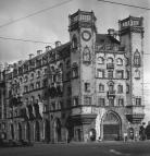
Mikhaylovskaya Street
MIKHAYLOVSKAYA STREET (known as Lassalya Street from 1918 to 1940, then called Brodskogo Street until 1991), between Nevsky Prospect and Iskusstv Square. The street, laid in 1834 after the design plan conceived by architect C.I
|
|
|
|
|
hidden
|
Millionnaya Street
MILLIONNAYA STREET [until 1738 - German settlement, until the middle of the 18th century - Bolshaya Nemetskaya Street, in the 1740-1800s - Bolshaya Millionnaya Street, in 1918-91 - Khalturina Street, after worker-revolutionary S.N
|
|
|
|
|
hidden
|
Mitrofanyevskoe Freeway
MITROFANYEVSKOE FREEWAY (until the 1890s - Bolshaya Mitrofanyevskaya Road), between the square of Baltiisky Railway Station and Yaltinskaya Street, parallel to Varshavskaya Railway Line
|
|
|
|
|
hidden
|
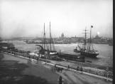
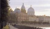
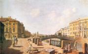
Moika, river
MOIKA (the original name Mya; known as Muya until the early 18th century, derived from the Izhora word for "slush, mire"), a river in the Neva river delta. The Moika River is 4.67 kilometres long, with a width of up to 40 metres
|
|
|
|
|
hidden
|
Mokhovaya Street
MOKHOVAYA STREET (until 1826 - Khamovaya Street or Khamovskaya Street), between Tchaikovskogo Street and Belinskogo Street. It was built up in the settlement of weavers ("khamovnik" - hence the first name)
|
|
|
|
|
hidden
|
Monetnaya Bolshaya Street
MONETNAYA BOLSHAYA STREET, between Kronverkskaya Street and Chapaeva Street. In the second half of the 18th century it was Third Matveevskaya Street (after St. Matthew’s Church)
|
|
|
|
|
hidden
|
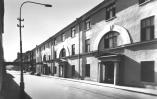
Morskaya Bolshaya Street
MORSKAYA BOLSHAYA STREET (in 1920-93 - Herzen Street, after A.I. Herzen), located from the General Staff Arch to Kryukov Canal. It was constructed in the early 18th century, in Morskaya settlement (hence the name)
|
|
|
|
|
hidden
|
Morskaya Embankment
MORSKAYA EMBANKMENT goes along the aggraded shore of the Gulf of Finland from the square in front of the Pribaltiyskaya Hotel to Nalichnaya Street (the name was given in 1972)
|
|
|
|
|
hidden
|
Morskaya Malaya Street
MORSKAYA MALAYA STREET (since 1738 - Bolshaya Lugovaya Street, since the middle of the 18th century until the 1820s - Novaya Isaakievskaya Street, in 1902-93 - Gogolya Street, after N.V. Gogol), between Nevsky Prospect and St. Isaac's Square
|
|
|
|
|