|
|
|
Addresses
/
Pulkovskoe Freeway/Saint Petersburg, city
hidden
|
Aviagorodok
AVIAGORODOK, an area in St. Petersburg's Moskovsky District, in the southern part of the city, west of Pulkovskoe Highway and near the Airport Railway Station. In 1931-41, it was Leningrad's main airport and included a living bloc for its staff
|
|
|
|
|
hidden
|
Hero-city Park
HERO-CITY PARK is situated in the south of St. Petersburg, between Pulkovskoe Highway, Moscovskoe Highway and Dunaysky Avenue. It was laid out on the site of orchards and vegetable gardens in 1972-80 and had an area of 25 hectares
|
|
|
|
|
hidden
|
Moskovskoe Freeway
MOSKOVSKOE FREEWAY, between Pobedy Square and line of the Circular Railway, continues Moskovsky Avenue. It appeared in the first quarter of the 18th century as the road to Sarskaya Myza (Tsarskoe Selo) and further on to Novgorod and Moscow (in the
|
|
|
|
|
hidden
|
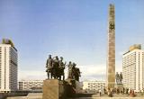
Pobedy Square
POBEDY SQUARE located at the intersection of Moskovsky Avenue, Moskovskoe Freeway, Pulkovskoe Freeway and Krasnoputilovskaya Street, and Ordzhonikidze Street. Until 1962
|
|
|
|
|
hidden
|
Predportovaya
PREDPORTOVAYA, a zone with industrial and storage facilities located between Kubinskaya Street, Dunaysky Avenue, Pulkovskoe Highway and Varshavskaya Railway Line
|
|
|
|
|
hidden
|
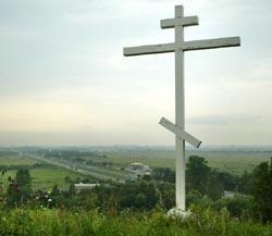
Pulkovo area
PULKOVO, an area in the south of St. Petersburg, at the junction of Kievskoe Freeway and the road from the town of Pushkin. It is located on Pulkovo heights. Since the 15th century
|
|
|
|
|
hidden
|
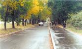
Pulkovskoe Freeway
PULKOVSKOE FREEWAY (until 1974, Kievskoe Freeway), from Pobedy Square to the city boundary, forms a continuation of Moskovsky Avenue, goes along the line of Pulkovsky meridian and closes on the dome of the Pulkovo Observatory
|
|
|
|
|
hidden
|
Srednyaya Rogatka
SREDNYAYA ROGATKA, the historical name of the area where Pulkovskoe Freeway and Moskovskoe Freeway intersect. In the 18th-19th centuries, an outpost was located there and the road was blocked with rogatka (turnpike) at night (hence the name)
|
|
|
|
|
|
hidden
|
|
hidden
|
|
hidden
|
|