Addresses
/
Leninsky Ave/Saint Petersburg, city
hidden
|
Central Ring Route
CENTRAL RING ROUTE, motor transport system, one of the main lines of St. Petersburg. The creation of Central Ring Route was to eliminate transit freight transport from the city
|
|
|
|
|
hidden
|
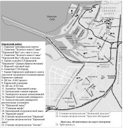
Kirovsky District
KIROVSKY DISTRICT is an administrative territorial unit of St. Petersburg. (Its territory administration is located at 18 Stachek Avenue). The district was named in honour of Sergey Kirov in 1934. Its present-day borders were established in 1973
|
|
|
|
|
hidden
|
Leninsky Avenue
LENINSKY AVENUE, running between Doblesti Street and Moskovskaya Square, part of the Central Circular Highway. It connects Yugo-Zapad and Ulyanka settlement, and Dachny and Moskovsky Avenues. The avenue, named in 1977 after V.I
|
|
|
|
|
hidden
|
Moskovskaya Square
MOSKOVSKAYA SQUARE, in the south part of Moskovsky Avenue, at its intersection with Leninsky Avenue and Tipanova Street. Occupying the territory of 13 hectares, it is recognised as the largest square in St. Petersburg
|
|
|
|
|
hidden
|
Moskovsky District
MOSKOVSKY DISTRICT is an administrative territorial unit of St. Petersburg. (Its territory administration is located at 129 Moskovsky Avenue) It was founded in 1919, and its present-day borders were established in 1965
|
|
|
|
|
hidden
|
Relief
RELIEF. Despite having a general plain character, its flatness and large built up areas, the relief of St. Petersburg is diverse and full of contrasts. The highest peaks in the southwest of the city reach 176 meters
|
|
|
|
|
hidden
|
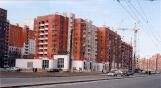
South-West
South-West, the region of large-scale residential development, a part of Krasnoselsky District territory to the north of Petergofskoe Freeway and to the west from Stachek Avenue
|
|
|
|
|
|
hidden
|