hidden
|
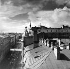
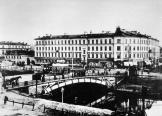
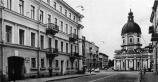
Moshkov Lane
MOSHKOV LANE named Zaporozhsky Lane after a Ukrainian city in 1952-89, between Dvortsovaya Embankment and Moika River Embankment. It was laid in the first quarter of the 18th century and named after houseowner and Master of the Household P. I
|
|
|
|
|
hidden
|
Moskovskaya Square
MOSKOVSKAYA SQUARE, in the south part of Moskovsky Avenue, at its intersection with Leninsky Avenue and Tipanova Street. Occupying the territory of 13 hectares, it is recognised as the largest square in St. Petersburg
|
|
|
|
|
hidden
|
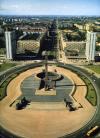
Moskovskoe Freeway
MOSKOVSKOE FREEWAY, between Pobedy Square and line of the Circular Railway, continues Moskovsky Avenue. It appeared in the first quarter of the 18th century as the road to Sarskaya Myza (Tsarskoe Selo) and further on to Novgorod and Moscow (in the
|
|
|
|
|
hidden
|
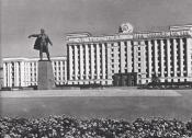
Moskovsky Avenue
MOSKOVSKY AVENUE (in 1918-50 - Mezhdunarodny Avenue, in 1950-56 - Stalina Avenue, after I.V. Stalin), from Sennaya Square to Pobedy Square, one of the main thoroughfares of St
|
|
|
|
|
hidden
|
Muzhestva Square
MUZHESTVA SQUARE known as Murinskaya or Spasskaya Square before 1965, between Karbysheva Street, Politekhnicheskaya Street, Second Murinsky Avenue, Toreza Avenue, and Nepokorennykh Avenue
|
|
|
|
|
hidden
|
Mytninskaya Embankment
MYTNINSKAYA EMBANKMENT stretching from Kronverksky Avenue to Dobrolyubova Avenue along Kronverksky Channel and the Malaya Neva River in the southern extremity of Petrogradsky Island at the approach of Birzhevoy Bridge
|
|
|
|
|
hidden
|
Narodnogo Opolchenia Avenue
NARODNOGO OPOLCHENIA AVENUE translated as Avenue of the People's Volunteer Corps, lying between Krasnoputilovskaya Street and Letchika Pilyutova Street and crossing districts of Knyazhevo, Dachnoe, Ulyanka, Ligovo, and Sosnovaya Polyana
|
|
|
|
|
hidden
|
Narvsky Avenue
NARVSKY AVENUE known as Novo-Peterhofsky Avenue before the 1880s, between Staro-Petergofsky Avenue and Stachek Square. It was named after the town of Narva. The avenue was laid in the first half of the 19th century as a part of Petergofsky Avenue
|
|
|
|
|
hidden
|
Nekrasova Street
NEKRASOVA STREET, known as Basseynaya Street before 1918, located between Liteyny Avenue and Grechesky Avenue. It was named after N. A. Nekrasov. It appeared in the first third of the 18th century leading to the pools that were opened to supply
|
|
|
|
|
hidden
|
Nepokorennykh Avenue
NEPOKORENNYKH AVENUE translated as the Avenue of the Unconquered, a part of the central ring road running between Muzhestva Square and Piskarevsky Avenue and crossing Kushelevka and Piskarevka
|
|
|
|
|
hidden
|
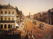
Nevsky Prospect
NEVSKY PROSPECT known as Bolshaya Pershpektivnaya Road or Bolshaya Pershpektiva until 1738, Nevskaya Prospektivaya Street or Nevskaya Perspektiva in 1738-1780s, and 25 October Avenue in 1918-44 so named in memory of the October Revolution of 1917
|
|
|
|
|
hidden
|
Novo-Admralty Canal
NOVO-ADMIRALTY CANAL (New Admiralty Canal) flowing from the confluence of the Moika River and the Admiraly Canal to the Bolshaya Neva was dug in the first quarter of the 18th century
|
|
|
|
|
hidden
|
Novo-Izmailovsky Avenue
NOVOIZMAILOVSKY AVENUE between Blagodatnaya Street and Konstitutsii Square. It was laid close to the former Korpusnoe Highway in the same direction as one of the three radial roads - Voznesensky Avenue and Izmailovsky Avenue (hence the name
|
|
|
|
|
hidden
|
Novosmolenskaya Embankment
NOVOSMOLENSKAYA EMBANKMENT known as Oktyabrskaya Embankment in 1976-87 and Smolenka River Embankment in 1987-89. It was laid downstream the Smolenka River along both banks of the straightened riverbed between Nalichnaya Street and Morskaya
|
|
|
|
|
hidden
|
Obukhovskoy Oborony Avenue
OBUKHOVSKOY OBORONY AVENUE from Alexandra Nevskogo Square to Karavaevskaya Street. It was laid in the early 18th century as a road to Arkhangelsk through Shlisselburg and was known as Shlisselburgskaya Road, Shlyutenburgskaya Road
|
|
|
|
|
hidden
|
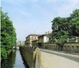
Obvodny Canal
OBVODNY CANAL flows from the Neva River in the area of Alexander Nevsky Lavra to the Ekaterinhofka River (8.08 km long, 21.3 meters wide and 42.6 meters wide in its eastern part)
|
|
|
|
|
hidden
|
Oktyabrskaya Embankment
OKTYABRSKAYA EMBANKMENT translated as October Embankment and known as Pravogo Berega Nevy Embankment before 1973. It runs between Zolnaya Street and Novosaratovka Settlement and crosses a number of settlements such as Klochki
|
|
|
|
|
hidden
|
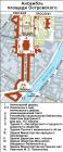
Ostrovskogo Square
OSTROVSKOGO SQUARE known as Alexandrinskaya Square before 1923, between Nevsky Prospect and Zodchego Rossi Street. It was renamed after playwright A. N. Ostrovsky (1823-86). The square was designed by architect K. I
|
|
|
|
|
hidden
|
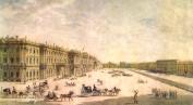
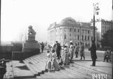
Palace Square
PALACE SQUARE, St. Petersburg's main square, the traditional location for city-wide festivities, and is part of the central square system of the Neva River's left bank
|
|
|
|
|
hidden
|
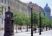
Pedestrian Zones (entry)
PEDESTRIAN ZONES. The first pedestrian zone in St. Petersburg was laid out on Malaya Konyushennaya Street after its reconstruction in 1995-97 (architect F. K. Romanovsky)
|
|
|
|
|
hidden
|
Perinnaya Line
PERINNAYA LINE lying along Bolshoy Gostiny Dvor between Nevsky Prospect and Lomonosova Street. In the mid-to-late 19th century, it was known as Surovskaya, or Bolshaya Surovskaya, Line (Textile Line) so named because of the goods sold in the line
|
|
|
|
|
hidden
|
Pesochnaya Embankment
PESOCHNAYA EMBANKMENT situated on Aptekarsky Island between Kamennoostrovsky Avenue and Karpovka River Embankment. It was laid on the left bank of the Malaya Nevka River in 1820s and named Pesochnaya Embankment (Sand Embankment) because of the sandy
|
|
|
|
|
hidden
|
Pestelya Street
PESTELYA STREET known as Panteleimonovskaya Street until 1923, between Fontanka River Embankment and Radishcheva Square. The street was named after P. I. Pestel
|
|
|
|
|
hidden
|
Petergofskaya Road
PETERGOFSKAYA ROAD (Petergofskaya Pershpektiva), name of Narvskaya Road between St. Petersburg and Peterhof in the 18th century. The road ran along the southern coast of the Gulf of Finland in place of the present-day Staro-Petergofsky Avenue
|
|
|
|
|
hidden
|
Petrogradskaya Embankment
PETROGRADSKAYA EMBANKMENT known as Peterburgskaya Embankment until 1914. It lies between Petrovskaya Embankment and Karpovka River Embankment on the left bank of the Neva River in the east of Petrogradsky Island (hence the name)
|
|
|
|
|
hidden
|
Petrovskaya Embankment
PETROVSKAYA EMBANKMENT lying between Troitskaya Square and Petrogradskaya Embankment on the right bank of the Neva River on Petrogradskaya Side. It appeared in what was then the city centre in the 1700s as the first embankment of St. Petersburg
|
|
|
|
|
hidden
|
Pionerskaya Square
PIONERSKAYA SQUARE between Zagorodny Avenue and the Young People's Theatre. It partly occupies the former vast ground of Semenovsky Lifeguard Regiment. Members of Petrashevsky's Circle were subjected to a mock execution in the ground in 1849 and
|
|
|
|
|
hidden
|
Pirogovskaya Embankment
PIROGOVSKAYA EMBANKMENT on the right bank of the Bolshaya Nevka River between Akademika Lebedeva Street and Maly Sampsonievsky Avenue. It consists of two sections. The first section, named after N. I
|
|
|
|
|
hidden
|
Pisareva Street
PISAREVA STREET known as Shafirovskaya Street from the mid-19th century and named Alexeevskaya Street after Grand Prince Alexey Alexeevich in 1887-1923 who had a palace at 122 Moika River Embankment
|
|
|
|
|
hidden
|
Piskarevsky Avenue
PISKAREVSKY AVENUE between Sverdlovskaya Embankment and the upper Okhta River near Novaya Village. It crosses Polyustrovo, Piskarevka (hence the name), and Ruchi
|
|
|
|
|