|
|
|
История переименований:
Rabochy Ave
(the 1930s - January 16, 1964)
Narodnogo Opolcheniya Ave
(as of January 16, 1964)
hidden
|
Alexandrino, forest park
ALEXANDRINO forest park is situated in the southwest part of St. Petersburg, between Narodnogo Opolcheniya Avenue, Stachek Avenue and Kozlova Street. It includes a park which formerly possessed the same name
|
|
|
|
|
hidden
|
Dachnoe
DACHNOE, an area in the south-west part of St. Petersburg, between Krasnenkaya River, Baltiiskaya Railway Line, Stachek Avenue and Alexandrino Forest Park. In the north, it borders Avtovo, in the south-west Ulyanka
|
|
|
|
|
hidden
|
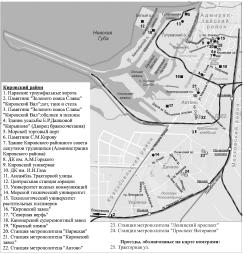
Kirovsky District
KIROVSKY DISTRICT is an administrative territorial unit of St. Petersburg. (Its territory administration is located at 18 Stachek Avenue). The district was named in honour of Sergey Kirov in 1934. Its present-day borders were established in 1973
|
|
|
|
|
hidden
|
Krasnoselsky District
KRASNOSELSKY DISTRICT is an administrative territorial unit of St. Petersburg. (Its territory administration is located at 3 Partizana Germana Street) Its present day borders were established in 1973. It was named after the town of Krasnoe Selo
|
|
|
|
|
hidden
|
Ligovsky Canal
LIGOVSKY CANAL was constructed to supply drinking water to St. Petersburg under the project of Grigory Skornyakov-Pisarev in 1718-21. Originally, it was 23 km long, 2-4 meters bottom-wide and 1-2 meters deep
|
|
|
|
|
hidden
|
Narodnogo Opolchenia Avenue
NARODNOGO OPOLCHENIA AVENUE translated as Avenue of the People's Volunteer Corps, lying between Krasnoputilovskaya Street and Letchika Pilyutova Street and crossing districts of Knyazhevo, Dachnoe, Ulyanka, Ligovo, and Sosnovaya Polyana
|
|
|
|
|
hidden
|
Sosnovaya Polyana
SOSNOVAYA POLYANA (Pine Glade), a park to the south-east of St. Petersburg between Veteranov Avenue and Narodnogo Opolchenia Avenue. From the west, it is confined by the Sosnovka River
|
|
|
|
|
hidden
|
Sosnovaya Polyana, the Park
SOSNOVAYA POLYANA is a park in the south-west of St. Petersburg between Veteranov Avenue and Narodnogo Opolcheniya Avenue. To the west is Sosnovka District. The total area is 58 hectares. The park was laid out in 1968
|
|
|
|
|
hidden
|
Toponymy of St. Petersburg
TOPONYMY OF ST. PETERSBURG, a corpus of names of geographical points situated on the territory of St. Petersburg. Names of rivers, islands, and villages located on the city's future territory appeared long before its foundation
|
|
|
|
|
hidden
|
Ulyanka
ULYANKA, an area to the south-west of St. Petersburg; in the north-east, it borders on Dachnoe (divided from it with Alexandrino forest park); in the west, it is confined with Marshal Zhukov Avenue, in the south - with Narodnogo Opolcheniya Avenue
|
|
|
|
|
|
hidden
|
|
hidden
|
|
hidden
|
|
hidden
|
|
hidden
|
|